Banks Island | |
|---|---|
 | |
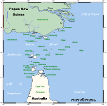
 A map of the Torres Strait Islands showing Moa in the northern central waters of Torres Strait | |
| Geography | |
| Location | Banks Channel, Northern Australia |
| Coordinates | 10°10′59″S 142°16′01″E / 10.183°S 142.267°E |
| Archipelago | Torres Strait Islands |
| Adjacent to | Torres Strait |
| Total islands | 1 |
| Administration | |
Australia | |
| State | Queensland |
| Local government area | Torres Strait Island Region |
| Demographics | |
| Ethnic groups | Torres Strait Islanders |
| Moa Island Queensland | |||||||||||||||
|---|---|---|---|---|---|---|---|---|---|---|---|---|---|---|---|
| Population | 432 (2021 census)[1] | ||||||||||||||
| • Density | 2.538/km2 (6.574/sq mi) | ||||||||||||||
| Postcode(s) | 4875 | ||||||||||||||
| Area | 170.2 km2 (65.7 sq mi) | ||||||||||||||
| Time zone | AEST (UTC+10:00) | ||||||||||||||
| LGA(s) | Torres Strait Island Region | ||||||||||||||
| State electorate(s) | Cook | ||||||||||||||
| Federal division(s) | Leichhardt | ||||||||||||||
| |||||||||||||||
Moa Island, also called Banks Island, is an island of the Torres Strait Islands archipelago that is located 40 kilometres (25 mi) north of Thursday Island in the Banks Channel of Torres Strait, Queensland, Australia.[2] It is also a locality within the Torres Strait Island Region local government area.[3] This island is the largest within the "Near Western" group. It has two towns, Kubin on the south-west coast and St Pauls on the east coast, which are connected by bitumen and a gravel road.[4][5] In the 2021 census, Moa Island had a population of 432 people.[1]
- ^ a b Cite error: The named reference
Census2021was invoked but never defined (see the help page). - ^ "Moa Island – Island in the Torres Strait Island Region (entry 22403)". Queensland Place Names. Queensland Government. Retrieved 2 October 2017.
- ^ "Moa Island – locality in the Torres Strait Island Region (entry 46706)". Queensland Place Names. Queensland Government. Retrieved 2 October 2017.
- ^ "Kubin – town in the Torres Strait Island Region (entry 18560)". Queensland Place Names. Queensland Government. Retrieved 2 October 2017.
- ^ "St Pauls – town in the Torres Strait Island Region (entry 29441)". Queensland Place Names. Queensland Government. Retrieved 2 October 2017.