Native name: Isla Mocha | |
|---|---|
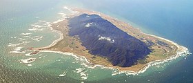
 Aerial view of Mocha Island | |
| Geography | |
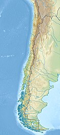
| Location | South-central Chile |
| Coordinates | 38°21′54″S 73°54′54″W / 38.36500°S 73.91500°W |
| Area | 48 km2 (19 sq mi) |
| Highest elevation | 300 m (1000 ft) |
| Administration | |
| Region | Bío Bío |
| Province | Arauco |
| Comuna | Lebu |
| Demographics | |
| Population | ~800 |
| Ethnic groups | Chileans, Mapuches |
Mocha Island (Spanish: Isla Mocha [ˈisla ˈmotʃa]) is a Chilean island located west of the coast of Arauco Province in the Pacific Ocean. It is approximately 48 km2 (19 sq mi) in area, with a chain of mountains running north–south. Mocha Island National Reserve covers approximately 45% of its surface. The island is the location of numerous historic shipwrecks. In Mapuche mythology, the souls of dead people travel west to visit this island.
The Pacific degu (Octodon pacificus), also known as the Mocha Island degu, a species of rodent in the family Octodontidae, is endemic to Mocha Island. The waters off the island are a popular place for recreational sea fishing.
