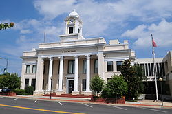
Mocksville, North Carolina | |
|---|---|
 Davie County Courthouse, Courthouse Square, September 2013 | |
| Motto: "Time Well Spent" | |
 Location of Mocksville, North Carolina | |
| Coordinates: 35°54′02″N 80°33′48″W / 35.90056°N 80.56333°W[1] | |
| Country | United States |
| State | North Carolina |
| County | Davie |
| Government | |
| • Mayor | William J. Marklin III[2] |
| Area | |
• Total | 7.79 sq mi (20.17 km2) |
| • Land | 7.77 sq mi (20.12 km2) |
| • Water | 0.02 sq mi (0.05 km2) |
| Elevation | 810 ft (250 m) |
| Population (2020) | |
• Total | 5,900 |
| • Density | 759.53/sq mi (293.25/km2) |
| Time zone | UTC-5 (Eastern (EST)) |
| • Summer (DST) | UTC-4 (EDT) |
| ZIP code | 27028 |
| Area code | 336 |
| FIPS code | 37-43720[4] |
| GNIS feature ID | 1021506[1] |
| Website | mocksvillenc |
Mocksville is a town in Davie County, North Carolina, United States. The population was 5,900 at the 2020 census. I-40 leads west to Statesville and Hickory, and east to Winston-Salem and Greensboro. Route 64 heads east to Lexington, and west towards Statesville and Taylorsville.[5] It is the county seat of Davie County.[6]
- ^ a b c U.S. Geological Survey Geographic Names Information System: Mocksville, North Carolina
- ^ "Elected Officials". Mocksville NC. Retrieved February 23, 2021.
- ^ "ArcGIS REST Services Directory". United States Census Bureau. Retrieved September 20, 2022.
- ^ "U.S. Census website". United States Census Bureau. Retrieved January 31, 2008.
- ^ "Geographic Identifiers: 2010 Demographic Profile Data (G001): Mocksville town, North Carolina". U.S. Census Bureau, American Factfinder. Archived from the original on February 13, 2020. Retrieved November 30, 2015.
- ^ "Find a County". National Association of Counties. Retrieved June 7, 2011.
