Mocoa | |
|---|---|
Municipality and city | |
 Plaza Central Mocoa in 2013 | |
| Nickname: The Head of Putumayo | |
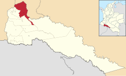
 Location of the town and municipality of Mocoa in Putumayo Department. | |
| Coordinates: 1°09′0″N 76°38′51″W / 1.15000°N 76.64750°W | |
| Country | |
| Region | Amazonía Region |
| Department | |
| Foundation | March 6, 1551 |
| Government | |
| • Mayor | Jose Antonio Castro |
| Area | |
| • Municipality and city | 1,305 km2 (504 sq mi) |
| • Urban | 5.61 km2 (2.17 sq mi) |
| Elevation | 604 m (1,982 ft) |
| Population (2018 census)[1] | |
| • Municipality and city | 56,398 |
| • Density | 43/km2 (110/sq mi) |
| • Urban | 38,457 |
| • Urban density | 6,900/km2 (18,000/sq mi) |
| Time zone | UTC-05 (Eastern Time Zone) |
Mocoa (Spanish pronunciation: [moˈko.a]) (Kamsá: Shatjok[2]) is a municipality and capital city of the department of Putumayo in Colombia.
The city is located in the northwest of the Putumayo department. The municipality borders the departments of Nariño to the west and Cauca to the north.
On March 31, 2017, mudslides in Mocoa left more than 254[3] people dead, and hundreds missing.[4]
- ^ Citypopulation.de Population of Mocoa municipality with localities
- ^ O'Brien, Colleen Alena (2018). A Grammatical Description of Kamsá, A Language Isolate of Colombia (PDF).
- ^ Brodzinsky, Sibylla (2017-04-02). "Colombia landslide leaves at least 254 dead and hundreds missing". The Guardian. ISSN 0261-3077. Retrieved 2017-04-03.
- ^ Brocchetto, Marilia; Ramos, Fernando; Sanchez, Ray. "Mudslides kill more than 200 people in Colombia". CNN. Retrieved 1 April 2017.

