| Moira River | |
|---|---|
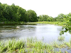
 Moira River on a warm afternoon | |
| Etymology | Named after Francis Rawdon-Hastings, Earl of Moira |
| Location | |
| Country | Canada |
| Province | Ontario |
| Region | Central Ontario |
| County | Hastings |
| Physical characteristics | |
| Source | Gunter |
| • location | Tudor and Cashel |
| • coordinates | 44°52′58″N 77°31′50″W / 44.88278°N 77.53056°W |
| • elevation | 360 m (1,180 ft) |
| Mouth | Bay of Quinte |
• location | Belleville |
• coordinates | 44°09′36″N 77°23′02″W / 44.16000°N 77.38389°W |
• elevation | 74.1 m (243 ft) |
| Length | 98 km (61 mi) |
| Basin features | |
| River system | Lake Ontario drainage basin |
| Tributaries | |
| • left | Palliser Creek, Chrysal Creek, Parks Creek, Clare River, Sulphide Creek, Skootamatta River, Black River, Madoc Creek |
| • right | Gawley Creek, Jordan River |
The Moira River is a river in Hastings County in eastern Ontario, Canada. It travels from its source in the centre of the county to the Bay of Quinte at the county seat Belleville .
