| Mojave Trails National Monument | |
|---|---|
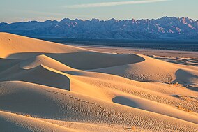
 Cadiz Dunes, Mojave Trails NM | |
| Location | San Bernardino County, California, U.S. |
| Coordinates | 34°36′N 116°00′W / 34.6°N 116°W |
| Area | 1,600,000 acres (650,000 ha) |
| Authorized | February 12, 2016 |
| Governing body | Bureau of Land Management |
| Website | Mojave Trails National Monument |
Mojave Trails National Monument is a large U.S. National Monument located in the state of California between Interstates 15 and 40.[1] The park was created to preserve a wide variety of geological and cultural features including several titular trails - the Old Spanish Trail, the World War II-era Desert Training Center and Route 66. It partially surrounds the Mojave National Preserve. It was designated by President Barack Obama on February 12, 2016, along with Castle Mountains National Monument and Sand to Snow National Monument, also in southern California.[2] It is under the administration of the Bureau of Land Management.
- ^ Sahagun, Louis (February 11, 2016). "Obama creates 3 new national monuments to protect 1.8 million acres of California desert". Los Angeles Times. Retrieved 2016-02-12.
- ^ Eilperin, Juliet. "The Washington Post". No. February 12, 2016. Retrieved February 12, 2016.

