Mokhotlong | |
|---|---|
 Mokhotlong Airport | |
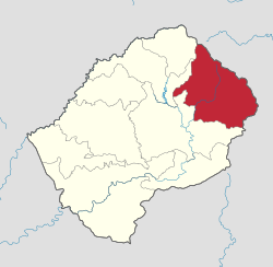
 Map of Lesotho with the district highlighted | |
| Country | |
| Capital | Mokhotlong |
| Government | |
| Area | |
• Total | 4,075 km2 (1,573 sq mi) |
| Elevation | 2,512[1] m (8,242 ft) |
| Population (2016) | |
• Total | 100,442 |
| • Density | 25/km2 (64/sq mi) |
| Time zone | UTC+2 (CAT) |
| Area code | +266 |
| HDI (2019) | 0.461[2] low · 9th |
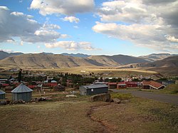
Mokhotlong district (in Sesotho language "the place of the bald ibis") is a district of Lesotho. It includes the highest terrain in the Maloti Mountains and the source of the Senqu River, Lesotho's primary watershed. Mokhotlong is the capital or camptown, and only town in the district. Mokhotlong borders on the KwaZulu-Natal Province of South Africa, with its north point bordering the Free State Province. Domestically, it borders on Butha-Buthe District in northwest, Leribe District in west, and Thaba-Tseka District in the south.
As of 2006, the district had a population of 97,713 which was 5.21 per cent of the total population of the country. The total area of the district was 4,075 which was 13.42 per cent of the total area of the country. The density of population in the district was 24.00 per km2. The total area planted in crops in 2009 was 16,420 hectares, which formed 4.07 per cent of the total area planted in crops in the country. The total agricultural production was 8,757 tonnes, which was 5.82 per cent of the total agricultural production in the country.
- ^ "Unnamed Road, Lesotho". Elevationmap.net. Retrieved 19 December 2018.
- ^ "Sub-national HDI - Area Database - Global Data Lab". hdi.globaldatalab.org. Retrieved 2018-09-13.