This article needs additional citations for verification. (August 2014) |
Mokopane
Potgietersrus | |
|---|---|
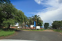
 Mokopane in 2013 | |
| Coordinates: 24°11′2″S 29°0′46″E / 24.18389°S 29.01278°E | |
| Country | South Africa |
| Province | Limpopo |
| District | Waterberg |
| Municipality | Mogalakwena |
| Area | |
• Total | 75.13 km2 (29.01 sq mi) |
| Elevation | 1,130 m (3,710 ft) |
| Population (2011)[1] | |
• Total | 30,151 |
| • Density | 400/km2 (1,000/sq mi) |
| Racial makeup (2011) | |
| • Black | 66.7% |
| • Coloured | 0.7% |
| • Indian/Asian | 4.4% |
| • White | 27.6% |
| • Other | 0.6% |
| First languages (2011) | |
| • Northern Sotho | 46.5% |
| • Afrikaans | 27.8% |
| • English | 7.4% |
| • Tsonga | 4.4% |
| • Other | 13.8% |
| Time zone | UTC+2 (SAST) |
| Postal code (street) | 0600 |
| PO box | 0600 |
| Area code | +27 (0)15 |
Mokopane,[2] formerly known as Potgietersrus, is a town in the Limpopo province of South Africa.
The town name was changed to Mokopane in 2003 in honour of a local Ma Nrebele leader, King Mghombane Gheghana, who ruled the area before being conquered by the Voortrekkers. Mokopane is the Northern Sotho form of the king's name and is hence erroneous, even though the majority language in the area is Northern Sotho. Five kingdoms in the vicinity of the town are Kekana (Moshate), Langa (Mapela), Lebelo (Garasvlei), and Langa (Bakenburg). It is still referred to as Potgietersrus or "Potties".
Two hours from Gauteng by road, the town acts as a getaway destination and as a stop-over for travelers "en route" to Botswana, Zimbabwe and Kruger National Park. The area is typical bushveld with many Vachellia and Senegalia trees (formerly part of the acacia genus) as well as aloes, which blooms in June and July. The Zebediela Citrus Estate, 55 km to the southeast, is one of the largest citrus farms in the southern hemisphere.
- ^ a b c d "Main Place Mokopane". Census 2011.
- ^ Mokopane infosite Archived 2018-05-21 at the Wayback Machine, googlebattle.com; accessed 27 August 2014.


