| Moksha | |
|---|---|
 | |
 Course of the Moksha | |
| Location | |
| Country | Russia |
| Region | Penza Oblast, Nizhny Novgorod Oblast, Republic of Mordovia, Ryazan Oblast |
| Cities | Temnikov, Krasnoslobodsk, Kovylkino |
| Physical characteristics | |
| Source | Vydygadovka |
| • location | Privolzhskaya Upland, Mokshansky District, Penza Oblast |
| • coordinates | 53°19′13″N 44°31′13″E / 53.3202°N 44.5203°E |
| Mouth | Oka |
• location | Pitelinsky District, Ryazan Oblast |
• coordinates | 54°44′35″N 41°52′42″E / 54.74306°N 41.87833°E |
• elevation | 79 m (259 ft) |
| Length | 656 km (408 mi) |
| Basin size | 51,000 km2 (20,000 sq mi) |
| Discharge | |
| • location | 72 km from the mouth |
| • average | 95 m3/s (3,400 cu ft/s) |
| Basin features | |
| Progression | Oka→ Volga→ Caspian Sea |
| Tributaries | |
| • left | Vad, Tsna |
| • right | Sivin, Satis |
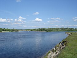
Moksha (Russian: Мо́кша, Moksha: Йов) is a river in central Russia, a right tributary of the Oka. It flows through Penza Oblast, Nizhny Novgorod Oblast, Ryazan Oblast and the Republic of Mordovia, and joins the Oka near Pyatnitsky Yar, near the city of Kasimov.
It is 656 kilometres (408 mi) in length, and has a drainage basin of 51,000 square kilometres (20,000 sq mi).[1]
In the 1950s, several hydroelectric power stations were built in the middle course of the river, but without navigable locks. In 1955, 2 km below the mouth of the river. Prices on the Moksha River built Rasypukhinsky hydro-power plant with a hydroelectric power station and a wooden shipping lock. Navigation on the river was carried out until the mid-1990s.
On the Moksha is the Trinity-Scans monastery, the Nativity-Theotokos Sanaksar Monastery and the Krasnoslobodsky Savior-Transfiguration Monastery.
- ^ «Река МОКША», Russian State Water Registry