Molenwaard | |
|---|---|
Former municipality | |
 A view of Kinderdijk at sunrise | |
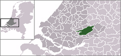
 Location in South Holland | |
| Coordinates: 51°52′N 4°47′E / 51.867°N 4.783°E | |
| Country | Netherlands |
| Province | South Holland |
| Municipality | Molenlanden |
| Established | 1 January 2013[1] |
| Merged | 1 January 2019 |
| Area | |
• Total | 126.47 km2 (48.83 sq mi) |
| • Land | 118.29 km2 (45.67 sq mi) |
| • Water | 8.18 km2 (3.16 sq mi) |
| Elevation | −1 m (−3 ft) |
| Population (January 2021)[4] | |
• Total | data missing |
| Time zone | UTC+1 (CET) |
| • Summer (DST) | UTC+2 (CEST) |
| Postcode | 2957–2977 |
| Area code | 0184 |
| Website | www |


Molenwaard[a] (Dutch pronunciation: [ˈmoːlə(ɱ)ˌʋaːrt]) is a former municipality in the western Netherlands, in the southeastern part of the province of South Holland, and the northwestern part of the region of Alblasserwaard. It was the result of a merger of the municipalities of Graafstroom, Liesveld, and Nieuw-Lekkerland on 1 January 2013. On 1 January 2019 it merged with Giessenlanden, together they form the new municipality of Molenlanden.[5] Molenwaard had about 29,000 inhabitants and an area of about 126 km2 (49 sq mi). The largest settlements are Bleskensgraaf, Groot-Ammers, and Nieuw-Lekkerland.
Molenwaard is a landscape of polders, consisting of large pastures traversed by ditches and canals, like the Groote- of Achterwaterschap, and the Ammersche Boezem. In the outermost northwest are the windmills of Kinderdijk. About 1.5 m below sea level, the municipality is bordered by the Lek river in the north and briefly the Noord river in the west. The Graafstroom and the Alblas flow through it.
Religiously, the municipality is part of the Bible Belt, resulting in the dominance of the Christian parties in politics.
- ^ "Gemeentelijke indeling op 1 januari 2013" [Municipal divisions on 1 January 2013]. cbs.nl (in Dutch). CBS. Retrieved 14 August 2013.
- ^ "Kerncijfers wijken en buurten 2020" [Key figures for neighbourhoods 2020]. StatLine (in Dutch). CBS. 24 July 2020. Retrieved 19 September 2020.
- ^ "Postcodetool for 2971VR". Actueel Hoogtebestand Nederland (in Dutch). Het Waterschapshuis. Retrieved 14 August 2013.
- ^ "Bevolkingsontwikkeling; regio per maand" [Population growth; regions per month]. CBS Statline (in Dutch). CBS. 1 January 2021. Retrieved 2 January 2022.
- ^ "Herindeling Molenwaard-Giessenlanden". Retrieved 3 January 2019.
Cite error: There are <ref group=lower-alpha> tags or {{efn}} templates on this page, but the references will not show without a {{reflist|group=lower-alpha}} template or {{notelist}} template (see the help page).
