You can help expand this article with text translated from the corresponding article in German. (June 2011) Click [show] for important translation instructions.
|
| Momhil Sar | |||
|---|---|---|---|
| Traditional Chinese | 莫慕希爾峰 | ||
| |||
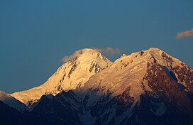
Momhil Sar (Urdu: مومہل سر), or Mumhail Sar as pronounced in Wakhi is at 7,414 metres (24,324 ft) above sea level, is the 64th highest mountain peak in the world.[1] Mumhail Sar in Wakhi means the mountain that overlooks or is above Grandmother's cattle pen or paddock. It is situated in Shimshal Valley the Hispar Muztagh subrange of the Karakoram range, a few kilometres to the north-west of its parent peak Trivor.
A group from the Styrian High-touring Section of the Austrian Alpine Association, led by Hanns Schell, made the first ascent on June 29, 1964. Initially they attempted to climb the southeast ridge but were unsuccessful so a few days later they returned to Camp 3 and crossed the southeast wall of Momhil Sar, Rudolf Pischinger, Hanns Schell, Horst Schindelbacher, Leo Schlömmer and Rudolf Widerhofer then reached the summit via the south ridge.[2][3]
- ^ a b "Momhil Sar, Pakistan". Peakbagger.com. Retrieved 12 December 2019.
- ^ a b "Asia, Pakistan, Momhil Sar". American Alpine Journal. American Alpine Club. 1965. Retrieved 12 December 2019.
- ^ Schindlbacher, Horst (1966). "Momhil Sar (24,090 feet)". Himalayan Journal. #27: 107–114. Retrieved 9 September 2024.


