| Monashee Mountains | |
|---|---|
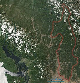
 Monashee Mountains are indicated. In the left of the image lies Vancouver Island. The boundary here includes the Okanagan Highland and portions of the Shuswap Highland. | |
| Highest point | |
| Peak | Mount Monashee |
| Elevation | 3,274 m (10,741 ft) |
| Coordinates | 52°23′07″N 118°56′24″W / 52.38528°N 118.94000°W |
| Dimensions | |
| Length | 530 km (330 mi) N-S |
| Width | 150 km (93 mi) W-E |
| Geography | |
| Countries |
|
| Provinces/States | |
| Parent range | Columbia Mountains |
The Monashee Mountains are a mountain range lying mostly in British Columbia, Canada, extending into the U.S. state of Washington. They stretch 530 km (329 mi) from north to south and 150 km (93 mi) from east to west. They are a sub-range of the Columbia Mountains. The highest summit is Mount Monashee, which reaches 3,274 m (10,741 ft). The name is from the Scottish Gaelic monadh and sìth, meaning "moor" and "peace".[1]
- ^ V., Akrigg, G. P. (1997). British Columbia place names. Akrigg, Helen B. (3rd ed.). Victoria, BC: UBC Press. ISBN 0774806362. OCLC 41086359.
{{cite book}}: CS1 maint: multiple names: authors list (link)
