Monmouthshire
Sir Fynwy (Welsh) | |
|---|---|
| |
| Motto(s): | |
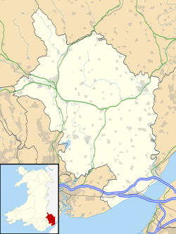
 Monmouthshire shown within Wales | |
| Coordinates: 51°47′N 2°52′W / 51.783°N 2.867°W | |
| Sovereign state | United Kingdom |
| Country | Wales |
| Preserved county | Gwent |
| Incorporated | 1 April 1996 |
| Administrative HQ | Usk |
| Government | |
| • Type | Principal council |
| • Body | Monmouthshire County Council |
| • Control | No overall control |
| • MPs | Catherine Fookes (L) |
| • MSs | +4 regional members |
| Area | |
| • Total | 328 sq mi (849 km2) |
| • Rank | 7th |
| Population (2022)[2] | |
| • Total | 93,886 |
| • Rank | 17th |
| • Density | 290/sq mi (111/km2) |
| Welsh language (2021) | |
| • Speakers | 8.7% |
| • Rank | 22nd |
| Time zone | UTC+0 (GMT) |
| • Summer (DST) | UTC+1 (BST) |
| ISO 3166 code | GB-MON |
| GSS code | W06000021 |
| Website | monmouthshire |
Monmouthshire (/ˈmɒnməθʃər, ˈmʌn-, -ʃɪər/ MON-məth-shər, MUN-, -sheer; Welsh: Sir Fynwy) is a county in the south east of Wales. It borders Powys to the north; the English counties of Herefordshire and Gloucestershire to the north and east; the Severn Estuary to the south, and Torfaen, Newport and Blaenau Gwent to the west. The largest town is Abergavenny, and the administrative centre is Usk.
The county is rural, although adjacent to the city of Newport and the urbanised South Wales Valleys; it has an area of 330 square miles (850 km2) and a population of 93,000. After Abergavenny (12,515), the largest towns are Chepstow (12,350), Monmouth (10,508), and Caldicot (9,813). The county has one of the lowest percentages of Welsh speakers in Wales, at 8.2% of the population in 2021.
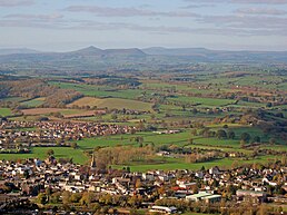
The lowlands in the centre of Monmouthshire are gently undulating, and shaped by the River Usk and its tributaries. The west of the county is hilly, and the Black Mountains in the northwest are part of the Brecon Beacons National Park (Bannau Brycheiniog). The border with England in the east largely follows the course of the River Wye and its tributary, the River Monnow. In the southeast is the Wye Valley AONB, a hilly region which stretches into England. The county has a shoreline on the Severn Estuary, with crossings into England by the Severn Bridge and Second Severn Crossing.
The name is identical to that of the historic county, of which the current local authority covers the eastern three-fifths. Between 1974 and 1996, the historic county was known as Gwent, recalling the medieval kingdom which covered a similar area. The present county was formed under the Local Government (Wales) Act 1994, which came into effect in 1996. In his essay 'Changes in local government', in the fifth and final volume of the Gwent County History, Robert McCloy writes, "the local government of no county in the United Kingdom in the twentieth century was so transformed as that of Monmouthshire".[4]
- ^ "Your Council". Monmouthshire County Council. June 2024. Retrieved 6 August 2024.
- ^ a b "Mid-Year Population Estimates, UK, June 2022". Office for National Statistics. 26 March 2024. Retrieved 3 May 2024.
- ^ "How life has changed in Monmouthshire: Census 2021". Office for National Statistics. 19 January 2023. Retrieved 6 August 2024.
- ^ McCloy 2013, p. 126.


