| Monongahela River | |
|---|---|
 The Monongahela River in Pittsburgh with South Side Pittsburgh on the right and Uptown Pittsburgh on the left | |
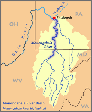
 Map of the Monongahela River basin with the Monongahela River highlighted | |
| Location | |
| Country | United States |
| State | Pennsylvania and West Virginia |
| Counties | Marion WV, Monongalia WV, Greene PA, Fayette PA, Washington PA, Westmoreland PA, Allegheny PA |
| Physical characteristics | |
| Source | Tygart Valley River |
| • location | Pocahontas County, West Virginia |
| • coordinates | 38°28′06″N 79°58′51″W / 38.46833°N 79.98083°W[1] |
| • elevation | 4,540 ft (1,380 m)[2] |
| 2nd source | West Fork River |
| • location | Upshur County, West Virginia |
| • coordinates | 38°51′08″N 80°21′32″W / 38.85222°N 80.35889°W[3] |
| • elevation | 1,309 ft (399 m)[4] |
| Source confluence | |
| • location | Fairmont, West Virginia |
| • coordinates | 39°27′53″N 80°09′10″W / 39.46472°N 80.15278°W[5] |
| • elevation | 863 ft (263 m)[3] |
| Mouth | Ohio River |
• location | Pittsburgh, Pennsylvania |
• coordinates | 40°26′30″N 80°00′58″W / 40.44167°N 80.01611°W[5] |
• elevation | 709 ft (216 m)[5] |
| Length | 130 mi (210 km)[6] |
| Basin size | 7,340 sq mi (19,000 km2)[7] |
| Discharge | |
| • location | Braddock, PA[8] |
| • average | 12,650 cu ft/s (358 m3/s) |
| • minimum | 2,900 cu ft/s (82 m3/s) |
| • maximum | 81,100 cu ft/s (2,300 m3/s) |
| Discharge | |
| • location | Masontown, PA[9] |
| • average | 8,433 cu ft/s (238.8 m3/s) |
| Basin features | |
| Tributaries | |
| • left | West Fork, Coal Run, Buffalo Creek, Hawkinberry Run, Paw Paw Creek, Pharoah Run, Parker Run, Indian Creek, Birchfield Run, Meadow Run, Broad Run, Dents Run, Scotts Run, Courtney Run, Robinson Run, Crooked Run, Dunkard Creek, Whiteley Creek, Little Whiteley Creek, Pegs Run, Muddy Creek, Noel Run, Pumpkin Run, Rush Run, Tenmile Creek, Fishpot Run, Barneys Run, Twomile Run, Lilly Run, Pike Run, Wood Run, Hooders Run, Maple Creek, Pigeon Creek, Dry Run, Mingo Creek, Huston Run, Lobbs Run, Peters Creek, Thompson Run, Homestead Run, West Run, Streets Run, Becks Run |
| • right | Tygart River, Prickett Creek, Little Creek, Whiteday Creek, Joes Run, Toms Run, Booths Run, Cobun Creek, Deckers Creek, West Run, Laurel Run, Camp Run, Cheat River, Georges Creek, Jacobs Creek, Cats Run, Browns Run, Middle Run, Antram Run, Wallace Run, Hereford Hollow, Bates Run, Meadow Run, Kelley Run, Rush Run, Dunlap Creek, Redstone Creek, Lamb Lick Run, Downers Run, Speers Run, Turkey Hollow, Beckers Run, Sunfish Run, Bunola Run, Kelly Run, Mill Run, Smiths Run, Fallen Timber Run, Wylie Run, Youghiogheny River, Crooked Run, Turtle Creek, Ninemile Run |
The Monongahela River (/məˌnɒŋɡəˈhiːlə/ mə-NONG-gə-HEE-lə, /-ˈheɪ-/ -HAY-),[10] sometimes referred to locally as the Mon (/mɒn/),[11] is a 130-mile-long (210 km)[6] river on the Allegheny Plateau in north-central West Virginia and Southwestern Pennsylvania. The river flows from the confluence of its west and east forks in north-central West Virginia northeasterly into southwestern Pennsylvania, then northerly to Pittsburgh and its confluence with the Allegheny River to form the Ohio River. The river includes a series of locks and dams that makes it navigable.
- ^ Geographic Names Information System. "Geographic Names Information System entry for Tygart Valley River (Feature ID #1553309)". Retrieved March 12, 2007.
- ^ Google Earth elevation for GNIS source coordinates. Retrieved on March 12, 2007.
- ^ a b Geographic Names Information System. "Geographic Names Information System entry for West Fork River (Feature ID #1548931)". Retrieved March 12, 2007.
- ^ Geographic Names Information System. "Geographic Names Information System entry for Straight Fork (headwaters tributary of West Fork River) (Feature ID #1547564)". Retrieved March 12, 2007.
- ^ a b c Geographic Names Information System. "Geographic Names Information System entry for Monongahela River (Feature ID #1209053)". Retrieved March 12, 2007.
- ^ a b U.S. Geological Survey. National Hydrography Dataset high-resolution flowline data. The National Map, accessed August 15, 2011
- ^ Gillespie, William H. (2006). "Monongahela River". In Ken Sullivan (ed.). The West Virginia Encyclopedia. Charleston, W.Va.: West Virginia Humanities Council. p. 492. ISBN 0-9778498-0-5.
- ^ United States Geological Survey; USGS 03085000 Monongahela River at Braddock, PA; retrieved September 29, 2010.
- ^ United States Geological Survey; USGS 03072655 Monongahela River near Masontown, PA; retrieved September 29, 2010.
- ^ There are several ways to pronounce this word that are acceptable. From "Geographical Names" of Merriam-Webster's Collegiate Dictionary, Eleventh Edition (2009): /məˌnɒnɡəˈhiːlə/, /məˌnɒɡəˈhiːlə/ or /məˌnɒŋɡəˈheɪlə/.
- ^ Gillespie, William H. (October 20, 2010). "The Monongahela River". e-WV: The West Virginia Encyclopedia. Retrieved October 18, 2024.