Monroe, New York | |
|---|---|
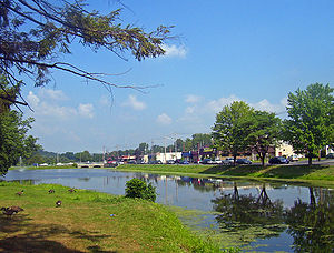
 Downtown Monroe, with mill pond and park in foreground | |
| Etymology: From Peter Jay Munroe, state senator | |
 Location in Orange County and the state of New York. | |
 Location of New York in the United States | |
| Coordinates: 41°19′27″N 74°11′13″W / 41.32417°N 74.18694°W | |
| Country | United States |
| State | New York |
| County | Orange |
| Settled | 1741 |
| Incorporated | 1894 |
| Government | |
| • Mayor | Neil Dwyer |
| Area | |
• Total | 3.56 sq mi (9.21 km2) |
| • Land | 3.49 sq mi (9.05 km2) |
| • Water | 0.06 sq mi (0.17 km2) |
| Elevation | 600 ft (200 m) |
| Highest elevation (Bald Hill (Monroe, New York)) | 890 ft (270 m) |
| Lowest elevation | 540 ft (160 m) |
| Population (2020) | |
• Total | 9,343 |
| • Density | 2,674.78/sq mi (1,032.64/km2) |
| Time zone | UTC-5 (Eastern (EST)) |
| • Summer (DST) | UTC-4 (EDT) |
| ZIP Code | 10950 |
| Area codes | 845 |
| FIPS code | 36-47988 |
| GNIS feature ID | 0957528 |
| Wikimedia Commons | Monroe, New York |
| Website | Village of Monroe |
Monroe is a village in Orange County, New York, United States. The population was 9,343 at the 2020 census. It is part of the Poughkeepsie–Newburgh–Middletown, NY Metropolitan Statistical Area as well as the larger New York–Newark–Bridgeport, NY-NJ-CT-PA Combined Statistical Area. The community is not named after President James Monroe, but rather after an early 19th-century New York state senator.
The Village of Monroe is in the northwestern part of the Town of Monroe by NY Route 17 (soon to be Interstate 86) and US 6. NY 17M is its main street.
- ^ "ArcGIS REST Services Directory". United States Census Bureau. Retrieved September 20, 2022.