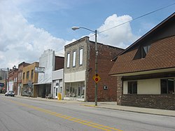
Monroeville, Indiana | |
|---|---|
 Downtown Monroeville | |
 Location of Monroeville in Allen County, Indiana. | |
| Coordinates: 40°58′22″N 84°52′7″W / 40.97278°N 84.86861°W | |
| Country | United States |
| State | Indiana |
| County | Allen |
| Township | Monroe |
| Area | |
• Total | 0.79 sq mi (2.05 km2) |
| • Land | 0.79 sq mi (2.05 km2) |
| • Water | 0.00 sq mi (0.00 km2) |
| Elevation | 787 ft (240 m) |
| Population (2020) | |
• Total | 1,294 |
| • Density | 1,633.84/sq mi (630.82/km2) |
| Time zone | UTC-5 (Eastern (EST)) |
| • Summer (DST) | UTC-4 (EDT) |
| ZIP code | 46773 |
| Area code | 260 |
| FIPS code | 18-50562[2] |
| GNIS feature ID | 0439348[3] |
Monroeville is a town in Monroe Township, Allen County, Indiana, United States. The population was 1,294 as of the 2020 census.
- ^ "2020 U.S. Gazetteer Files". United States Census Bureau. Retrieved March 16, 2022.
- ^ "U.S. Census website". United States Census Bureau. Retrieved January 31, 2008.
- ^ "US Board on Geographic Names". United States Geological Survey. October 25, 2007. Retrieved January 31, 2008.