Mont-Joli | |
|---|---|
 Notre-Dame-de-Lourdes de Mont-Joli Church | |
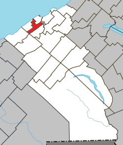
 Location within La Mitis RCM | |
| Coordinates: 48°35′N 68°11′W / 48.58°N 68.18°W[1] | |
| Country | |
| Province | |
| Region | Bas-Saint-Laurent |
| RCM | La Mitis |
| Constituted | 13 June 2001 |
| Government | |
| • Mayor | Martin Soucy |
| • Federal riding | Avignon—La Mitis—Matane—Matapédia |
| • Prov. riding | Matane-Matapédia |
| Area | |
• Total | 24.30 km2 (9.38 sq mi) |
| • Land | 24.24 km2 (9.36 sq mi) |
| Elevation | 75 m (246 ft) |
| Population | |
• Total | 6,384 |
| • Density | 263.3/km2 (682/sq mi) |
| • Pop 2016–2021 | |
| • Dwellings | 3,173 |
| Time zone | UTC−5 (EST) |
| • Summer (DST) | UTC−4 (EDT) |
| Postal code(s) | |
| Area code(s) | 418 and 581 |
| Highways | |
| Website | www |
Mont-Joli (French: [mɔ̃ ʒɔli]) is a city in the La Mitis Regional County Municipality within the Bas-Saint-Laurent region of Quebec, Canada. It is the county seat. The city is located east of Rimouski near the south shore of the Saint Lawrence River.


