| Mont Dolent | |
|---|---|
 Mont Dolent | |
| Highest point | |
| Elevation | 3,823 m (12,543 ft) |
| Prominence | 330 m (1,080 ft)[1] |
| Parent peak | Aiguille Verte |
| Listing | Alpine mountains above 3000 m |
| Coordinates | 45°55′21″N 7°2′46″E / 45.92250°N 7.04611°E |
| Geography | |
| Location | Aosta Valley, Italy Valais, Switzerland Haute-Savoie, France |
| Parent range | Graian Alps |
| Climbing | |
| First ascent | 9 July 1864 by A. Reilly, Edward Whymper, Michel Croz, H. Charlet and M. Payot |
| Easiest route | South face and south-east ridge (PD) |

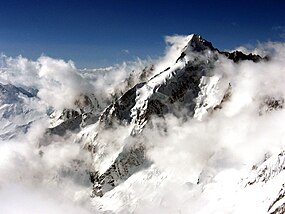
Mont Dolent (3,823 metres (12,543 ft)) is a mountain in the Mont Blanc massif and lies on the border between Italy, Switzerland and France.
As a mountain, Mont Dolent is regarded as the tripoint between Italy, Switzerland and France, although the tripoint itself lies at 3,749 metres, less than 100 metres north-west of its summit.[2][3][4]
In 1954, a statue of the Virgin Mary was erected on Mont Dolent's summit by the young people of Valais.
- ^ Retrieved from the Swisstopo and IGN topographic maps. The key col is Col du Dolent (3,490 m).
- ^ Portale Cartografico Nazionale Archived 2009-09-05 at the Wayback Machine
- ^ "Italy – Switzerland Boundary" (PDF). Florida State University. International Boundary Study. US. Department of State. 23 October 1961. Archived from the original (PDF) on 10 June 2016. Retrieved 22 August 2016.
- ^ Cartes IGN (Map). L'Institut national de l'information géographique et forestière. Retrieved 22 August 2016.
