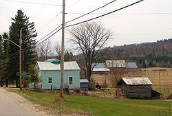
Montcerf-Lytton | |
|---|---|
 | |
 Location within La Vallée-de-la-Gatineau RCM | |
| Coordinates: 46°32′N 76°03′W / 46.533°N 76.050°W[1] | |
| Country | Canada |
| Province | Quebec |
| Region | Outaouais |
| RCM | La Vallée-de-la-Gatineau |
| Constituted | September 19, 2001 |
| Government | |
| • Mayor | Véronique Danis |
| • Federal riding | Pontiac |
| • Prov. riding | Gatineau |
| Area | |
• Total | 379.67 km2 (146.59 sq mi) |
| • Land | 354.12 km2 (136.73 sq mi) |
| Population (2021)[3] | |
• Total | 653 |
| • Density | 1.8/km2 (5/sq mi) |
| • Pop (2016–21) | |
| • Dwellings | 387 |
| Time zone | UTC−5 (EST) |
| • Summer (DST) | UTC−4 (EDT) |
| Postal code(s) | |
| Area code | 819 |
| Website | www |
Montcerf-Lytton is a municipality in La Vallée-de-la-Gatineau Regional County Municipality, Quebec, Canada. Its territory spans both shores of the Désert River, a tributary of the Gatineau River.
Its population centres include: Brodeur, Chute-Rouge, Lytton, and Montcerf.
Montcerf has one of the best soil for cultivation across the Gatineau Valley region, supplemented by a network of lakes (most notably Clair, Desrivières, and Lytton Lakes) and forests, which are part of the Zec Bras-Coupé–Désert.[4] Fishing and hunting are popular sport activities in this place.[5]
- ^ Cite error: The named reference
toponymiewas invoked but never defined (see the help page). - ^ a b Cite error: The named reference
mamrotwas invoked but never defined (see the help page). - ^ a b "Montcerf-Lytton, Municipalité (MÉ) Census Profile, 2021 Census of Population". www12.statcan.gc.ca. Government of Canada - Statistics Canada. Retrieved 5 January 2023.
- ^ "Lytton (Canton)" (in French). Commission de toponymie du Québec. Retrieved 2008-08-21.
- ^ "Montcerf (Municipalité)" (in French). Commission de toponymie du Québec. Retrieved 2008-08-21.
