| Monte Pissis | |
|---|---|
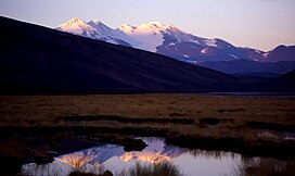
 Monte Pissis from the northeast | |
| Highest point | |
| Elevation | 6,792 m (22,283 ft)[1] |
| Prominence | 2,145 m (7,037 ft)[2][A] |
| Listing | |
| Coordinates | 27°45′19″S 68°47′57″W / 27.75528°S 68.79917°W[3] |
| Geography | |
| Location | La Rioja and Catamarca provinces, Argentina |
| Parent range | Andes |
| Geology | |
| Mountain type | Stratovolcano |
| Climbing | |
| First ascent | 1937 by Osiecki and Jan Alfred Szczepański |
| Easiest route | Hike, east side |
Monte Pissis is an extinct volcano on the border of the La Rioja and Catamarca provinces in Argentina, 25 km (16 mi) to the east of the Chilean border and about 550 km (340 mi) north of Aconcagua. The mountain is the third-highest in the Western Hemisphere. Monte Pissis is named after Pedro José Amadeo Pissis, a French geologist who worked for the Chilean government. Due to its location in the Atacama Desert, the mountain has very dry conditions but features an extensive glacier, with crevasses, which is unique in the region. The peak is the highest summit on Earth without a permanent glacier.[4]
- ^ "Phillipe Reuter: "El Ojos del Salado es 100 metros más alto que el Pissis"". Archived from the original on 2011-07-08. Retrieved 2007-05-24.
- ^ "Argentina and Chile North: Ultra-Prominences". Andes Specialists. 2020. Archived from the original on 2020-04-07. Retrieved 2020-04-11.
- ^ "Andean Mountains - All above 5000m". Archived from the original on 2020-04-07. Retrieved 2020-04-11.
- ^ "Do All Mountains Wear Snowcaps?". wonderopolis.org/wonder. Wonderopolis.
Cite error: There are <ref group=upper-alpha> tags or {{efn-ua}} templates on this page, but the references will not show without a {{reflist|group=upper-alpha}} template or {{notelist-ua}} template (see the help page).
