| Monte Rosa | |
|---|---|
| Monte Rosa massif | |
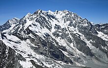
 Central Monte Rosa massif, with Dufourspitze to the south (right) and Nordend to the north (left), the Monte Rosa Glacier right below on its western wing, the upper Gorner Glacier on the left, and the Grenzgletscher to the right. The nearly vertical eastern wall (behind, not visible) has a height greater than the visible part in front. | |
| Highest point | |
| Peak | Dufourspitze |
| Elevation | 4,634 m (15,203 ft) |
| Listing | Country high point Canton high point Ultra |
| Coordinates | 45°56′13″N 07°52′00″E / 45.93694°N 7.86667°E |
| Naming | |
| Native name | |
| Geography | |
| Countries | |
| Canton, Regions | |
| Parent range | Pennine Alps, Western Alps |
| Topo map | swisstopo: 3 – Suisse sud-ouest[1] |
| Climbing | |
| First ascent | 1 August 1855 by Matthäus and Johannes Zumtaugwald, Ulrich Lauener, Christopher and James Smyth, Charles Hudson, John Birkbeck and Edward Stephenson. |
| Easiest route | rock/snow/ice climb |
Monte Rosa (Italian: [ˈmonte ˈrɔːza]; Lombard: Mont Roeusa [ˌmũː(t) ˈrøːza]; French: Mont Rose [mɔ̃ ʁoz]; Walser: de Gletscher or de Gorner; German: Monte Rosa) is a mountain massif in the eastern part of the Pennine Alps, on the border between Italy (Piedmont and Aosta Valley) and Switzerland (Valais). The highest peak of the massif, amongst several peaks of over 4,000 m (13,000 ft), is the Dufourspitze (4,634 m, 15,203 ft), the second highest mountain in the Alps and western Europe, after Mont Blanc.[2] The east face of the Monte Rosa towards Italy has a height of about 2,400 metres (7,900 ft) and is the highest mountain wall of the Alps.
The group is on the watershed between the Rhône and Po basins and has a topographic prominence of 2,165 metres (7,103 ft) which is ranked fifth in the Alps.
The Monte Rosa massif has four faces. Three are in Italy: the Liskamm heading above the Val de Gressoney; the Valsesian face above Alagna Valsesia at the upper part of the Valle della Sesia; and the steep, big east wall above Macugnaga in the Valle Anzasca. The Swiss north-western face has several glaciers (with one of the largest Alpine glaciers) flowing towards the Mattertal with Zermatt.[1]
Its main summit, named Dufourspitze in honor of the surveyor Guillaume-Henri Dufour and wholly located in Switzerland,[3] culminates at 4,634 m (15,203 ft) and is followed by the five nearly equally high subsidiary summits of Dunantspitze, Grenzgipfel, Nordend, Zumsteinspitze, and Signalkuppe. Some other peaks over 4,000 m (13,000 ft), such as Piramide Vincent, Punta Giordani, and Corno Nero, are wholly in Italy. Monte Rosa is the highest mountain in both Switzerland and the Pennine Alps and is also the second-highest mountain in the Alps and in Europe outside of the Caucasus.[1][4][5]
The north-west side of the central Monte Rosa massif, with its enormous ice slopes and seracs, constitutes the boundary and upper basin of the large Gorner Glacier, which descends towards Zermatt and merges with its nowadays much larger tributary, the Grenzgletscher (lit. 'Border Glacier'), right below the Monte Rosa Hut on the lower end of the visible western wing. The Grenzgletscher is an impressive glacier formation between the western wing of the mountain and Liskamm, a ridge on its southwestern side on the Swiss-Italian border. On the eastern side, in Italy, the mountain falls away in an almost vertical 2,400-metre-high (7,900 ft) wall of granite and ice, the biggest in Europe, overlooking Macugnaga and several smaller glaciers.[1]

Monte Rosa was studied by pioneering geologists and explorers, including Leonardo da Vinci in the late fifteenth century and Horace-Bénédict de Saussure in the late eighteenth century. Following a long series of attempts beginning in the early nineteenth century, Monte Rosa's summit, then still called Höchste Spitze (lit. 'highest peak'), was first reached in 1855 from Zermatt by a party of eight climbers led by three guides. The great east wall was first climbed in 1872, from Macugnaga.[citation needed]
Each summer many climbers set out from the Monte Rosa Hut on the mountain's west wing for one of its summits via the normal route or for the Margherita Hut on the Signalkuppe (Italian: Punta Gnifetti), used as a research station. Many tourists and hikers also come to the Gornergrat on the northwest side of the massif to see a panorama that extends over some of the highest peaks in the Alps.
- ^ a b c d "3 – Suisse sud-ouest" (Map). Monte Rosa massif (2018 ed.). 1:200 000. National Map 1:200'000. Wabern, Switzerland: Federal Office of Topography – swisstopo. 2018. ISBN 978-3-302-00003-9. Retrieved 2019-04-20 – via map.geo.admin.ch.
- ^ John Ball, A Guide to the Western Alps, pp. 308-314
- ^ "Dufourspitze | mountain, Switzerland". Encyclopedia Britannica. Retrieved 2020-01-06.
- ^ Reinhold Messner, The big walls: from the North Face of the Eiger to the South Face of Dhaulagiri, p. 23
- ^ The Caucasus Mountains, which include higher peaks than the Alps, are usually included on political maps of Europe, although not systematically. If the Europe–Asia border is defined north of the Caucasus, Monte Rosa is the second-highest summit in Europe after Mont Blanc (or third if Mont Blanc de Courmayeur is considered as a summit).
- ^ Steffen Kern: Die fünf gewaltigsten Wände der Welt. outdoor-magazin.com, 30. September 2014 (in German)

