| Monte San Giorgio | |
|---|---|
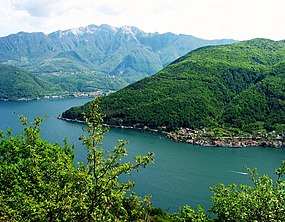
 Monte San Giorgio (right), among Lake Lugano and Monte Generoso (left, background) | |
| Highest point | |
| Elevation | 1,097 m (3,599 ft) |
| Prominence | 758 m (2,487 ft)[1] |
| Coordinates | 45°54′49″N 8°56′59″E / 45.91361°N 8.94972°E |
| Geography | |
| Location | Ticino, Switzerland |
| Parent range | Lugano Prealps |
| Topo map | Swisstopo 1373 Mendrisio |
| Climbing | |
| Easiest route | Trail |
| Official name | Monte San Giorgio |
| Type | Natural |
| Criteria | viii |
| Designated | 2003 (27th session) |
| Reference no. | 1090 |
| Region | Europe and North America |
| Extensions | 2010 |
Monte San Giorgio is a Swiss mountain and UNESCO World Heritage Site near the border between Switzerland and Italy. It is part of the Lugano Prealps, overlooking Lake Lugano in the Swiss Canton of Ticino.
Monte San Giorgio is a wooded mountain, rising to 1,097 m (3,600 feet) above sea level. It has a roughly pyramidal shape, with a steep north edge sloping towards Lake Lugano and a more shallow South Slope extending towards the Po Plain. The eastern (Swiss) side of the mountain, between the municipalities of Brusino Arsizio, Riva San Vitale, and Meride, was listed as a World Heritage Site in 2003. This was in recognition of its cultural, biological, and especially paleontological significance. The site is renowned for its fossil content, one of the best known records of marine life in the Middle Triassic period.[2][3][4] The Italian region west of Poncione d'Arzo (Porto Ceresio) was added as an extension to the World Heritage Site in 2010.[5]
- ^ Swisstopo map
- ^ Monte San Giorgio – UNESCO World Heritage Centre
- ^ "Nomination of Monte San Giorgio for inclusion in the World Heritage List" (PDF). UNESCO World Heritage Centre. 2003.
- ^ Rieppel, Olivier (2019). Mesozoic Sea Dragons: Triassic Marine Life from the Ancient Tropical Lagoon of Monte San Giorgio. Bloomington, IN: Indiana University Press. ISBN 978-0-253-04013-8.
- ^ "Nomination of Monte San Giorgio (Italian extension of Monte San Giorgio, Switzerland, inscribed in 2003) for inscription on the UNESCO World Heritage List" (PDF). UNESCO World Heritage Centre. 2010.


