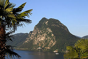
| Monte San Salvatore | |
|---|---|
 | |
| Highest point | |
| Elevation | 912 m (2,992 ft) |
| Prominence | 602 m (1,975 ft)[1] |
| Coordinates | 45°58′37.3″N 8°56′50.1″E / 45.977028°N 8.947250°E |
| Geography | |
| Location | Ticino, Switzerland |
| Parent range | Lugano Prealps |
| Climbing | |
| Easiest route | Hike or ride Monte San Salvatore funicular |
The Monte San Salvatore (912 m) is a mountain in the Lepontine Alps above Lake Lugano and the city of Lugano in Switzerland. The Monte San Salvatore funicular links the city with the summit of the mountain.
One of the villages on the slopes of Monte San Salvatore, Carona, is a popular destination to enjoy views over Lake Lugano and to walk through the exotic plants and flowers of Parco San Grato.[2]
