| Monticello Dam | |
|---|---|
 | |
| Location | Vaca Mountains, Napa County, California. |
| Coordinates | 38°30′48″N 122°06′15″W / 38.5133°N 122.1042°W |
| Construction began | 1953 |
| Opening date | 1957 |
| Operator(s) | Bureau of Reclamation |
| Dam and spillways | |
| Impounds | Putah Creek |
| Height | 304 ft (93 m) |
| Length | 1,023 ft (312 m) |
| Width (base) | 100 ft (30 m) |
| Reservoir | |
| Creates | Lake Berryessa |
| Total capacity | 1,602,000 acre⋅ft (1.976×10⁹ m3) |
| Catchment area | 566 sq mi (1,470 km2)[1] |
| Surface area | 20,700 acres (8,400 ha) |
| Power Station | |
| Operator(s) | Solano Irrigation District |
| Commission date | 1983 |
| Turbines | 2 × 5 MW, 1 × 1.5 MW |
| Installed capacity | 11.5 MW |
| Annual generation | 56,806,000 KWh (2004)[2] |
| U.S. Geological Survey Geographic Names Information System: Monticello Dam | |

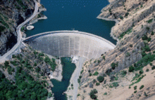
Monticello Dam is a 304-foot (93 m) high concrete arch dam in Napa County, California, United States, constructed between 1953 and 1957. The dam impounded Putah Creek to create Lake Berryessa in the Vaca Mountains.
Lake Berryessa is currently the seventh-largest man-made lake in California. Water from the reservoir primarily supplies agriculture in the Sacramento Valley downstream. The dam is noted for its classic, uncontrolled morning-glory-type spillway.[1] The diameter at the lip is 72 ft (22 m).
To the south is Putah Creek State Wildlife Area.
- ^ a b Cite error: The named reference
USBR Hydrologywas invoked but never defined (see the help page). - ^ "Monticello (7646)". Carbon Monitoring for Action. Retrieved April 22, 2014.