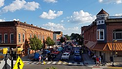
Montpelier, Ohio | |
|---|---|
 Downtown Montpelier | |
 Location of Montpelier, Ohio | |
 Location of Montpelier in Williams County | |
| Coordinates: 41°34′54″N 84°35′48″W / 41.58167°N 84.59667°W | |
| Country | United States |
| State | Ohio |
| County | Williams |
| Village of Montpelier | 1845 |
| Area | |
| • Total | 2.88 sq mi (7.47 km2) |
| • Land | 2.87 sq mi (7.44 km2) |
| • Water | 0.01 sq mi (0.03 km2) |
| Elevation | 863 ft (263 m) |
| Population (2020) | |
| • Total | 3,942 |
| • Density | 1,371.61/sq mi (529.52/km2) |
| Time zone | UTC-5 (Eastern (EST)) |
| • Summer (DST) | UTC-4 (EDT) |
| ZIP code | 43543 |
| Area code | 419 |
| FIPS code | 39-51772[3] |
| GNIS feature ID | 2399390[2] |
| Website | Montpelier, OH |
Montpelier (/mɒntˈpiːljər/ mont-PEEL-yər)[5] is a village in Williams County, Ohio, United States. The population was 3,942 at the 2020 census.
- ^ "ArcGIS REST Services Directory". United States Census Bureau. Retrieved September 20, 2022.
- ^ a b U.S. Geological Survey Geographic Names Information System: Montpelier, Ohio
- ^ "U.S. Census website". United States Census Bureau. Retrieved January 31, 2008.
- ^ "Montpelier, OH - Government".
- ^ "E.W. Scripps School of Journalism Ohio Pronunciation Guide | Ohio University". www.ohio.edu. Ohio University. 2016. Retrieved January 2, 2024.