Montsevelier | |
|---|---|
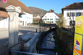
 Montsevelier river in Montsevelier village | |
| Coordinates: 47°21′N 07°30′E / 47.350°N 7.500°E | |
| Country | Switzerland |
| Canton | Jura |
| District | Delémont |
| Area | |
| • Total | 7.75 km2 (2.99 sq mi) |
| Elevation | 565 m (1,854 ft) |
| Population (2011) | |
| • Total | 508 |
| • Density | 66/km2 (170/sq mi) |
| Time zone | UTC+01:00 (Central European Time) |
| • Summer (DST) | UTC+02:00 (Central European Summer Time) |
| Postal code(s) | 2828 |
| SFOS number | 472 |
| ISO 3166 code | CH-JU |
| Surrounded by | Mervelier, Corban, Bärschwil(SO), Grindel(SO), Erschwil(SO), Beinwil(SO) |
| Website | www SFSO statistics |
Montsevelier (French pronunciation: [mɔ̃səv(ə)lje]) is a former municipality in the district of Delémont in the canton of Jura in Switzerland. The municipalities of Montsevelier, Vermes and Vicques merged on 1 January 2013 into the new municipality of Val Terbi.[1]
- ^ Amtliches Gemeindeverzeichnis der Schweiz published by the Swiss Federal Statistical Office (in German) accessed 2 January 2013


