This article needs additional citations for verification. (June 2016) |
Monzuno | |
|---|---|
| Comune di Monzuno | |
 Monzuno | |
| Coordinates: 44°17′N 11°16′E / 44.283°N 11.267°E | |
| Country | Italy |
| Region | Emilia-Romagna |
| Metropolitan city | Bologna (BO) |
| Frazioni | Bologna, Brento, Ca' di Giulietta, Carbonarolo, Gabbiano, La Trappola, Lodole, Montorio, Pian di Lama, Rioveggio, San Niccolò, San Rocco, Selve, Trasasso, Vado, Valle |
| Government | |
| • Mayor | Marco Mastacchi |
| Area | |
• Total | 65 km2 (25 sq mi) |
| Elevation | 621 m (2,037 ft) |
| Population (30 November 2017)[2] | |
• Total | 6,359 |
| • Density | 98/km2 (250/sq mi) |
| Time zone | UTC+1 (CET) |
| • Summer (DST) | UTC+2 (CEST) |
| Postal code | 40036 |
| Dialing code | 051 |
| Patron saint | St. Louis |
| Saint day | Last Sunday in August |
| Website | Official website |
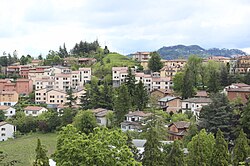
Monzuno (Bolognese: Munżón) is an Italian comune in the Metropolitan City of Bologna (Emilia-Romagna).
The territory of the commune is located on the western slope of the Savena valley, on the northern ridge of Monte Venere and on the left side of the Setta and Sambro streams.
- ^ "Superficie di Comuni Province e Regioni italiane al 9 ottobre 2011". Italian National Institute of Statistics. Retrieved 16 March 2019.
- ^ "Popolazione Residente al 1° Gennaio 2018". Italian National Institute of Statistics. Retrieved 16 March 2019.


