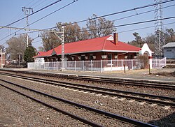
Mooi River | |
|---|---|
 Mooirivier railway station | |
| Coordinates: 29°12′S 29°59′E / 29.200°S 29.983°E | |
| Country | South Africa |
| Province | KwaZulu-Natal |
| District | Umgungundlovu |
| Municipality | Mpofana |
| Area | |
• Total | 13.76 km2 (5.31 sq mi) |
| Elevation | 1,393 m (4,570 ft) |
| Population (2011)[1] | |
• Total | 17,779 |
| • Density | 1,300/km2 (3,300/sq mi) |
| Racial makeup (2011) | |
| • Black African | 91.6% |
| • Coloured | 1.0% |
| • Indian/Asian | 3.5% |
| • White | 3.6% |
| • Other | 0.2% |
| First languages (2011) | |
| • Zulu | 82.75% |
| • English | 7.8% |
| • Afrikaans | 0.8% |
| • Sotho | 0.8% |
| • Other | 7.85% |
| Time zone | UTC+2 (SAST) |
| PO box | 3300 |
| Area code | 033 |
Mooi River (Zulu: eMpafana, Afrikaans: Mooirivier) is a small town situated at 1,389 m above sea level and 160 km from the coast in KwaZulu-Natal, South Africa. The first European settlement in the area was at Mooi River Drift in 1852. This was formally named Weston in 1866 after the first Governor of Natal, Martin West.
- ^ a b c d Sum of the Main Places Bruntville, Mooi River and Townview from Census 2011.

