| Moose Mountain Creek | |
|---|---|
 Moose Mountain Creek | |
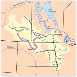
 The Red River drainage basin, with the Souris River highlighted | |
| Location | |
| Countries | |
| Province | |
| Communities | |
| Physical characteristics | |
| Source | Chapleau Lakes, near Montmartre |
| • location | Saskatchewan |
| • elevation | 668 m (2,192 ft) |
| Mouth | Souris River |
• location | South-west of Oxbow, Saskatchewan |
• coordinates | 49°12′55″N 102°11′47″W / 49.21537°N 102.19634°W |
• elevation | 512 m (1,680 ft) |
| Discharge | |
| • location | Souris River, west of Oxbow |
| Basin features | |
| River system | Red River drainage basin |
| Tributaries | |
| • left | Wolf Creek, Crooked Creek, Swift Creek |
| • right | Morrison Creek, Cowper Creek, Shepherd Creek |
| [1][2] | |
Moose Mountain Creek is a river[3] in the Canadian province of Saskatchewan. Its source is the Chapleau Lakes near Montmartre and it is a tributary of the Souris River, which, in turn, is a tributary of the Assiniboine River. The whole system is part of the Red River watershed, which is part of the Hudson Bay drainage basin and in a region called the Prairie Pothole Region of North America, which extends throughout three Canadian provinces and five U.S. states. It is also within Palliser's Triangle and the Great Plains ecoregion.[4]
The entirety of Moose Mountain Creek is in Census Division No. 1. The river passes through two Indian reserves, Ocean Man and Pheasant Rump, and eight rural municipalities: Montmartre, Chester, Golden West, Tecumseh, Brock, Moose Mountain, Moose Creek, and Enniskillen.[5] While there are no communities along the banks of the river, there are four within two kilometres of its banks: Montmartre, Kisbey, Alameda, and Oxbow. The original location of Carlyle, NW 26-07-03 W2, was located near confluence of Moose Mountain, Swift, and Morrison Creeks.
Moose Mountain Creek flows generally in a south-easterly direction, starting north-west of Moose Mountain Upland and ending up at the Souris River near Oxbow. The western and southern regions of Moose Mountain fall within the river's watershed, which is part of the Upper Souris watershed. The northern most point of Moose Mountain Creek's watershed is near McLean, which is only 41 kilometres (25 mi) away from Saskatchewan's capital, Regina.[6][7]
There are two major dams along the river. The first one is Moose Mountain Dam and the second is Grant Devine Dam, both of which created large reservoirs along the course. Both reservoirs have parks; Lost Horse Hills is on Moose Mountain Lake and Moose Creek Regional Park[8] is on Grant Devine Reservoir.
- ^ "Natural Resources Canada-Canadian Geographical Names (Moose Mountain Creek)". Retrieved 29 August 2014.
- ^ "Atlas of Canada Toporama". Retrieved 29 August 2014.
- ^ Government of Canada, Natural Resources Canada. "Place names - Moose Mountain Creek". www4.rncan.gc.ca.
- ^ Bonikowsky, Laura (14 July 2013). "Drought in Palliser's Triangle". The Canadian Encyclopedia. Retrieved 7 September 2024.
- ^ "SARM Member Divisions". SARM.ca. SARM. Retrieved 8 September 2024.
- ^ "Map of the Upper Souris Watershed". Upper Souris Watershed. Upper Souris Watershed Association. Retrieved 8 September 2024.
- ^ "Watershed Resources". Caring for Our Watersheds. Nutrien. Retrieved 8 September 2024.
- ^ "Moose Creek". Regional Parks of Saskatchewan. Saskatchewan Regional Parks. Retrieved 22 August 2024.

