| Moose River | |
|---|---|
 | |
| Location | |
| Country | United States |
| Physical characteristics | |
| Source | |
| • location | Maine |
| • elevation | 1,930 feet (590 m) |
| Mouth | |
• location | Moosehead Lake |
• coordinates | 45°40′55″N 69°45′58″W / 45.68194°N 69.76611°W |
• elevation | 1,029 feet (314 m) |
| Length | 83 miles (134 km) |
| Basin features | |
| River system | Kennebec River |
| Tributaries | |
| • right | South Branch Moose River |
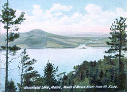
The Moose River is an 83-mile-long (134 km)[1] river in Maine. Its source (45°32′24″N 70°41′46″W / 45.5400°N 70.6961°W) is in Beattie (Maine Township 2, Range 8, WBKP), on the Canada–United States border, which runs along the height of land between the watersheds of the Kennebec River in Maine and the Chaudière River in Quebec. From there, the river runs east through Attean Pond and Wood Pond, past the town of Moose River, then through Long Pond and Brassua Lake. The Moose River empties into Moosehead Lake, the source of the Kennebec River, in Rockwood Strip (T1, R1, WBKP). The International Railway of Maine was built along Moose River in 1889.[2]
- ^ U.S. Geological Survey. National Hydrography Dataset high-resolution flowline data. The National Map, accessed June 30, 2011
- ^ Johnson, Ron (1985). The Best of Maine Railroads. Portland Litho.

