Morang District
मोरङ जिल्ला | |
|---|---|
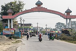
 Entrance to Biratnagar | |
 | |
| Country | |
| Province | Koshi Province |
| Established | 7th century circa |
| Admin HQ. | Biratnagar |
| Government | |
| • Type | Coordination committee |
| • Body | DCC, Morang |
| • Head | Mr. Naresh Prasad Pokhrel |
| • Deputy-Head | Mr. Prakash Kumar Shah |
| • Parliamentary constituencies | 6 |
| • Provincial constituencies | 12 |
| Area | |
| • Total | 1,855 km2 (716 sq mi) |
| Elevation | 111 m (364 ft) |
| Highest elevation | 2,410 m (7,910 ft) |
| Lowest elevation | 60 m (200 ft) |
| Population (2021)[1] | |
| • Total | 1,147,187 |
| • Rank | 1st (in Province) |
| • Density | 620/km2 (1,600/sq mi) |
| Time zone | UTC+05:45 (NPT) |
| Main Language(s) | Nepali, Maithili, Tharu, Rajbanshi, Limbu |
| Minor Language(s) | Newar, Angika, Urdu, Magar, Tamang |
| Website | www |
Morang District (Nepali: मोरङ जिल्ला ) is located in Koshi Province in eastern Nepal. It is an Outer Terai district, which borders Jhapa to the east, Dhankuta and Panchthar to the north, Sunsari to the west, and Bihar, India, to the south. Morang has one metropolitan city (Biratnagar), eight municipalities and eight rural municipalities. The total area of the district is 1,855 km2 (716 sq mi). The lowest elevation point is 60 meters and the highest is 2,410 meters above sea level. The headquarters of Morang is connected by the Koshi National Highway to the east–west Mahendra National Highway at Itahari, Sunsari. Morang is also connected to the Hill parts of the eastern region of Nepal. Morang is the core industrial sector for the eastern region of Nepal.
At the beginning of the 7th century, King Mung Mawrong Hang came to prominence in the terai lands of Limbuwan (present-day Sunsari, Morang and Jhapa area). He cleared much of the forest area in present-day Rangeli, east of Biratnagar, and built a town there. He named his Kingdom Morang after his name and rose to power.[2][3]
The lowlands of Limbuwan (present-day terai lands of Sunsari, Morang and Jhapa) was collectively known as Morang since the time of King Mawrong. In the beginning of 1400 AD, Morang Kingdom patriated from Kingdom of Ilam and Kingdom of Mikluk Bodhey (Choubise) and started ruling on its own. Morang Kingdom’s borders were set at Kankai river in the east, Koshi river in the west, Shanguri fort in the north and Jalal garh in India in the south. King Sangla Ing became the first king of Lowland Limbuwan kingdom of Morang after 900 years since it last had its own king. He built alliances with the other Kings of Limbuwan and remained in good terms. He built his kingdom at Varatappa and ruled from there. King Sangla Ing was succeeded by his son Pungla Ing, who later converted into Hinduism and changes his name to Amar Raya Ing.[4]
- ^ Household and population by districts, Central Bureau of Statistics (CBS) Nepal Archived 2013-07-31 at the Wayback Machine
- ^ Chemjong, Iman Sing. History and Culture of Kirant People.
- ^ "Yakthung Phedap Limbuwan Royal Order". Yakthung Phedap Limbuwan Royal Order- 2019. Phedap. 8 December 2019.
- ^ Chemjong, Iman Singh. History and Culture of Kirat People (4th ed.).