This article needs additional citations for verification. (November 2012) |
Morar
| |
|---|---|
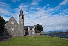
 Our Lady of Perpetual Succour & St Cumin, Morar | |
Location within the Lochaber area | |
| Population | 257 [1] |
| OS grid reference | NM677929 |
| • London | 532 mi (856 km) |
| Council area | |
| Country | Scotland |
| Sovereign state | United Kingdom |
| Post town | Mallaig |
| Postcode district | PH40 |
| Dialling code | 01687 462 |
| Police | Scotland |
| Fire | Scottish |
| Ambulance | Scottish |
Morar (/ˈmɔːrər/; Scottish Gaelic: Mòrar) is a small village on the west coast of The Rough Bounds of Scotland, three miles (five kilometres) south of Mallaig. The name Morar is also applied to the northern part of the peninsula containing the village, though North Morar is more usual (the region to the south west of Loch Morar is known as Arisaig, rather than South Morar). The coastline of the area forms part of the Morar, Moidart and Ardnamurchan National Scenic Area,[2] one of 40 such areas in Scotland, which are defined so as to identify areas of exceptional scenery and to ensure its protection by restricting certain forms of development.[3]
Morar has a railway station on the West Highland Line and is by-passed by the A830, part of the Road to the Isles, between Fort William and Mallaig. The village was formed of the farms and crofts of Bourblach, Beoraid Beg and Beoraid Mor with the modern village growing up around the railway station of Morar during the 20th century. The 1911 census suggests that the village name was not yet in regular use at the time, as only the old settlement names are used in it.
- ^ "2001 Census profile for Morar". The Highland Council. Archived from the original on 21 December 2004.
- ^ "National Scenic Areas - Maps". SNH. 20 December 2010. Archived from the original on 12 June 2018. Retrieved 14 May 2018.
- ^ "National Scenic Areas". Scottish Natural Heritage. Retrieved 14 May 2018.
