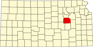
Morris County | |
|---|---|
 Madonna of the Trail monument in Council Grove | |
 Location within the U.S. state of Kansas | |
 Kansas's location within the U.S. | |
| Coordinates: 38°42′N 96°36′W / 38.7°N 96.6°W | |
| Country | |
| State | |
| Founded | February 11, 1859 |
| Named for | Thomas Morris |
| Seat | Council Grove |
| Largest city | Council Grove |
| Area | |
| • Total | 703 sq mi (1,820 km2) |
| • Land | 695 sq mi (1,800 km2) |
| • Water | 7.6 sq mi (20 km2) 1.1% |
| Population | |
| • Total | 5,386 |
| • Estimate (2023)[2] | 5,334 |
| • Density | 7.7/sq mi (3.0/km2) |
| Time zone | UTC−6 (Central) |
| • Summer (DST) | UTC−5 (CDT) |
| Congressional district | 2nd |
| Website | MorrisCountyKS.org |
Morris County is a county located in the U.S. state of Kansas. Its county seat and largest city is Council Grove. As of the 2020 census, the county population was 5,386.[1] The county was named for Thomas Morris, a U.S. Senator from Ohio and anti-slavery advocate.
- ^ a b "QuickFacts; Morris County, Kansas; Population, Census, 2020 & 2010". United States Census Bureau. Archived from the original on August 16, 2021. Retrieved August 16, 2021.
- ^ "Annual Estimates of the Resident Population for Counties: April 1, 2020 to July 1, 2023". United States Census Bureau. Retrieved March 24, 2024.