Morrisonville, Wisconsin | |
|---|---|
Former unincorporated community | |
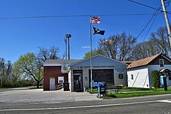
 Morrisonville post office | |
| Coordinates: 43°16′38″N 89°21′34″W / 43.27722°N 89.35944°W | |
| Country | |
| State | |
| County | Dane County |
| Elevation | 293 m (961 ft) |
| Time zone | UTC-6 (Central (CST)) |
| • Summer (DST) | UTC-5 (CDT) |
| ZIP code | 53571[1] |
| Area code | 608 |
| GNIS feature ID | 1569760[2] |
Morrisonville is an unincorporated community in the village of Windsor, in Dane County, Wisconsin, United States, approximately 18 miles (29 km) north of Madison.[2][3] The Yahara River flows through the community. The main road running through Morrisonville is County Trunk DM, which connects from State Highway 51 approximately 8 miles (13 km) to the village of Dane, Wisconsin. At each entrance into the town on DM is a welcome sign calling Morrisonville "Frogtown U.S.A."[4]
- ^ "Morrisonville ZIP Code". zipdatamaps.com. 2022. Retrieved November 30, 2022.
- ^ a b "Morrisonville, Wisconsin". Geographic Names Information System. United States Geological Survey, United States Department of the Interior.
- ^ Morrisonville, Wisconsin
- ^ "Town of Windsor Meeting Minutes". Archived from the original on October 5, 2006. Retrieved April 22, 2009.

