Morrow County | |
|---|---|
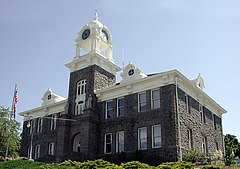
 Morrow County Courthouse in Heppner | |
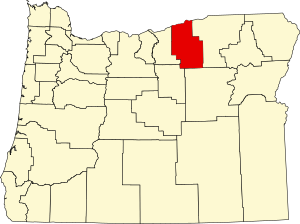
 Location within the U.S. state of Oregon | |
 Oregon's location within the U.S. | |
| Coordinates: 45°25′N 119°34′W / 45.42°N 119.57°W | |
| Country | |
| State | |
| Founded | February 16, 1885 |
| Named for | Jackson L. Morrow |
| Seat | Heppner |
| Largest city | Boardman |
| Area | |
• Total | 2,049 sq mi (5,310 km2) |
| • Land | 2,032 sq mi (5,260 km2) |
| • Water | 17 sq mi (40 km2) 0.8% |
| Population (2020) | |
• Total | 12,186 |
• Estimate (2023) | 12,302 |
| • Density | 5.9/sq mi (2.3/km2) |
| Time zone | UTC−8 (Pacific) |
| • Summer (DST) | UTC−7 (PDT) |
| Congressional district | 2nd |
| Website | www |
Morrow County is one of the 36 counties in the U.S. state of Oregon. As of the 2020 census, the population was 12,186.[1] The county seat is Heppner.[2] The county is named for one of its first settlers, Jackson L. Morrow, who was a member of the state legislature when the county was created. Half of the Umatilla Chemical Depot, which includes the Umatilla Chemical Agent Disposal Facility, and the Naval Weapons Systems Training Facility Boardman are located within the county. Morrow County is part of the Pendleton-Hermiston, OR, Micropolitan Statistical Area. It is located on the south side of the Columbia River and is included in the eight-county definition of Eastern Oregon.
- ^ "State & County QuickFacts". United States Census Bureau. Retrieved May 20, 2023.
- ^ "Find a County". National Association of Counties. Retrieved June 7, 2011.