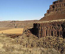
Moses Coulee is a canyon in the Waterville plateau region of Douglas County, Washington. Moses Coulee is the second-largest and westernmost canyon of the Channeled Scablands, located about 30 kilometres (19 mi) to the west of the larger Grand Coulee. This water channel is now dry, but during glacial periods, large outburst floods with discharges greater than 600,000 m3/s (21,000,000 cu ft/s) carved the channel.[1] While it's clear that glacial floodwaters passed through and contributed to the erosion of Moses Coulee, the age of those waters, thus the origins of the coulee are less clear. No clear connection between the head of the coulee and major flood routes to the north, east, or west is known. Some researchers propose that floods from glacial Lake Missoula formed Moses Coulee,[2] while others suggest that subglacial floods from the Okanogan Lobe incised the canyon.[3] The mouth of Moses Coulee discharges into the Columbia River.
Two National Natural Landmarks were established in 1986 for features, notable as the best examples of their kind, in and around Moses Coulee. The Great Gravel Bar of Moses Coulee, on the western edge of Moses Coulee where US Highway 2 crosses the coulee, is described as "the largest and best example of a pendant river bar formed by catastrophic glacial outburst floods that swept across the Columbia Plateau prior to the last Pleistocene glaciation." Withrow Moraine and Jameson Lake Drumlin Field "contains the best examples of drumlins and the most illustrative segment of the only Pleistocene terminal moraine in the Columbia Plateau biophysiographic province. ... They are also the only such glacial features in the world to show a clear geological relationship to catastrophic flooding." The canyon is named for Chief Moses (1829–99).[4]
- ^ Larsen, Isaac J.; Lamb, Michael P. (October 2016). "Progressive incision of the Channeled Scablands by outburst floods". Nature. 538 (7624): 229–232. Bibcode:2016Natur.538..229L. doi:10.1038/nature19817. ISSN 0028-0836. PMID 27734850. S2CID 4385469.
- ^ Waitt, Richard B. (2016-05-01). "Megafloods and Clovis cache at Wenatchee, Washington". Quaternary Research. 85 (3): 430–444. Bibcode:2016QuRes..85..430W. doi:10.1016/j.yqres.2016.02.007. ISSN 0033-5894. S2CID 133054690.
- ^ Lesemann, Jerome-Etienne; Brennand, Tracy A. (2009-11-01). "Regional reconstruction of subglacial hydrology and glaciodynamic behaviour along the southern margin of the Cordilleran Ice Sheet in British Columbia, Canada and northern Washington State, USA". Quaternary Science Reviews. 28 (23–24): 2420–2444. Bibcode:2009QSRv...28.2420L. doi:10.1016/j.quascirev.2009.04.019. ISSN 0277-3791.
- ^ Meany, Edmond S. (1923). Origin of Washington geographic names. Seattle: University of Washington Press. p. 172.