Moses Lake, Washington | |
|---|---|
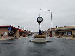
 Downtown Moses Lake | |
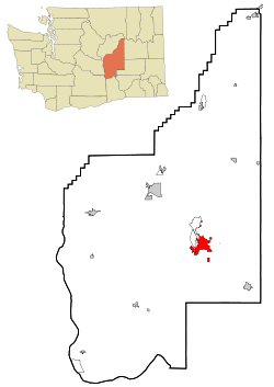
 Location of Moses Lake in Grant County, Washington | |
| Coordinates: 47°7′16″N 119°17′18″W / 47.12111°N 119.28833°W | |
| Country | United States |
| State | Washington |
| County | Grant |
| Founded | 1911 |
| Incorporated | September 15, 1938 |
| Government | |
| • Type | Council–manager[1] |
| • Mayor | Don Myers |
| Area | |
• City | 21.10 sq mi (54.65 km2) |
| • Land | 18.14 sq mi (46.97 km2) |
| • Water | 2.96 sq mi (7.67 km2) |
| Elevation | 1,070 ft (326 m) |
| Population | |
• City | 25,146 |
• Estimate (2023)[6] | 26,299 |
| • Density | 1,450.13/sq mi (559.89/km2) |
| • Urban | 38,751[3] |
| • Metro | 102,678 (US: 29th) |
| Time zone | UTC–8 (Pacific (PST)) |
| • Summer (DST) | UTC–7 (PDT) |
| ZIP Code | 98837 |
| Area code | 509 |
| FIPS code | 53-47245 |
| GNIS feature ID | 1512481[4] |
| Website | cityofml.com |
Moses Lake is a city in Grant County, Washington, United States. The population was 25,146 as of the 2020 census.[5] Moses Lake is the largest city in Grant County. The city anchors the Moses Lake Micropolitan area, which includes all of Grant County and is part of the Moses Lake–Othello combined statistical area.
Moses Lake, on which the city lies, is made up of three main arms over 18 miles (29 km) long and up to one mile (1.6 km) wide. It is the largest natural body of fresh water in Grant County and has over 120 miles (190 km) of shoreline covering 6,500 acres (2,600 ha). Before it was dammed in the early 1900s and then incorporated into the Columbia Basin Project, Moses Lake was a smaller shallow lake.[7] To the south of the town is the Potholes Reservoir and the Columbia National Wildlife Refuge that has a number of seep lakes and vast amounts of migratory birds and other fauna natural to the area.
- ^ "City Council". City of Moses Lake. Retrieved January 4, 2024.
- ^ "2024 U.S. Gazetteer Files". United States Census Bureau. Retrieved November 19, 2024.
- ^ "2020 Census Qualifying Urban Areas and Final Criteria Clarifications". Federal Register. United States Census Bureau. December 29, 2022.
- ^ a b U.S. Geological Survey Geographic Names Information System: Moses Lake, Washington
- ^ a b "Explore Census Data". United States Census Bureau. Retrieved January 4, 2024.
- ^ Cite error: The named reference
USCensusEst2023was invoked but never defined (see the help page). - ^ U.S. Geological Survey Geographic Names Information System: Moses Lake, USGS, GNIS