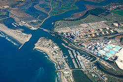
Moss Landing, California | |
|---|---|
 Aerial view | |
 Location in Monterey County and the state of California | |
| Coordinates: 36°48′16″N 121°47′13″W / 36.80444°N 121.78694°W | |
| Country | |
| State | |
| County | Monterey |
| Government | |
| • State senator | John Laird (D)[1] |
| • Assemblymember | Robert Rivas (D)[1] |
| • U.S. Rep. | Jimmy Panetta (D)[2] |
| Area | |
• Total | 0.602 sq mi (1.56 km2) |
| • Land | 0.392 sq mi (1.02 km2) |
| • Water | 0.210 sq mi (0.54 km2) 34.88% |
| Elevation | 10 ft (3 m) |
| Population | |
• Total | 237 |
| • Density | 604.6/sq mi (233.4/km2) |
| Time zone | UTC-8 (Pacific) |
| • Summer (DST) | UTC-7 (PDT) |
| ZIP code | 95039 |
| Area code | 831 |
| FIPS code | 06-49488 |
| GNIS feature IDs | 1659184, 2408874 |
Moss Landing, formerly Moss,[6] is an unincorporated community and census-designated place (CDP) in Monterey County, California, United States.[4] It is located 18 miles (29 km) north-northeast of Monterey, at an elevation of 10 feet (3.048 m).[4] It is on the shore of Monterey Bay, at the mouth of Elkhorn Slough and at the head of the submarine Monterey Canyon.
- ^ a b "Statewide Database". UC Regents. Archived from the original on February 1, 2015. Retrieved November 29, 2014.
- ^ "California's 19th Congressional District - Representatives & District Map". Civic Impulse, LLC. Retrieved June 15, 2024.
- ^ "2022 U.S. Gazetteer Files: California". United States Census Bureau. Retrieved November 21, 2022.
- ^ a b c U.S. Geological Survey Geographic Names Information System: Moss Landing, California
- ^ "P1. Race – Moss Landing CDP, California: 2020 DEC Redistricting Data (PL 94-171)". U.S. Census Bureau. Retrieved November 21, 2022.
- ^ Durham, David L. (1998). California's Geographic Names: A Gazetteer of Historic and Modern Names of the State. Clovis, Calif.: Word Dancer Press. ISBN 1-884995-14-4.
