| Moss Vale New South Wales | |||||||||||||||
|---|---|---|---|---|---|---|---|---|---|---|---|---|---|---|---|
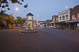
 Argyle Street, which forms part of the Illawarra Highway | |||||||||||||||
| Coordinates | 34°33′S 150°23′E / 34.550°S 150.383°E | ||||||||||||||
| Population | 8,774 (UCL 2021)[1] | ||||||||||||||
| Established | 1861 | ||||||||||||||
| Postcode(s) | 2577 | ||||||||||||||
| Elevation | 678 m (2,224 ft) | ||||||||||||||
| Location |
| ||||||||||||||
| LGA(s) | Wingecarribee Shire | ||||||||||||||
| Region | Southern Highlands | ||||||||||||||
| County | Camden | ||||||||||||||
| Parish | Bong Bong | ||||||||||||||
| State electorate(s) | Goulburn | ||||||||||||||
| Federal division(s) | Whitlam | ||||||||||||||
| |||||||||||||||
| |||||||||||||||
Moss Vale is a town in the Southern Highlands of New South Wales, Australia, in the Wingecarribee Shire. It is located on the Illawarra Highway, which connects to Wollongong and the Illawarra coast via Macquarie Pass.
Moss Vale has several heritage buildings. In the centre of the main street is Leighton Gardens. Moss Vale has undergone recent (2019) gentrification. It has become a hub for independent and creative businesses, including design stores, cafes, and bars. The town has a commercial district and a golf course, including a large parkland, Cecil Hoskins Nature Reserve.
- ^ Australian Bureau of Statistics (28 June 2022). "Moss Vale (urban centre and locality)". Australian Census 2021.
