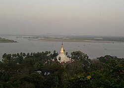
Mottama
| |
|---|---|
Town | |
 | |
| Coordinates: 16°31′48″N 97°36′08″E / 16.53000°N 97.60222°E | |
| Country | |
| State | |
| District | Thaton District |
| Population | |
| • Ethnicities | Mon Burman Karen |
| • Religions | Theravada Buddhism |
| Time zone | UTC+6:30 (MST) |
Look up မုဟ်တၟံ in Wiktionary, the free dictionary.
Mottama (Burmese: မုတ္တမမြို့, pronounced [moʊʔtəma̰ mjo̰]; Muttama Mon: မုဟ်တၟံ, [mùh mɔˀ]; formerly Martaban) is a town in the Thaton District of Mon State, Myanmar. Located on the west bank of the Thanlwin river (Salween), on the opposite side of Mawlamyaing, Mottama was the capital of the Martaban Kingdom (later known as Hanthawaddy Kingdom) from 1287 to 1364, and an entrepôt of international repute until the mid-16th century.
