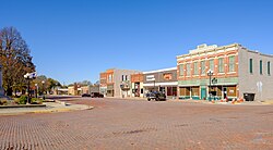
Mount Ayr, Iowa | |
|---|---|
 | |
 Location of Mount Ayr, Iowa | |
| Coordinates: 40°42′51″N 94°14′15″W / 40.71417°N 94.23750°W | |
| Country | |
| State | |
| County | Ringgold |
| Area | |
| • Total | 2.72 sq mi (7.05 km2) |
| • Land | 2.70 sq mi (6.99 km2) |
| • Water | 0.02 sq mi (0.05 km2) |
| Elevation | 1,234 ft (376 m) |
| Population (2020) | |
| • Total | 1,623 |
| • Density | 601.11/sq mi (232.10/km2) |
| Time zone | UTC-6 (Central (CST)) |
| • Summer (DST) | UTC-5 (CDT) |
| ZIP code | 50854 |
| Area code | 641 |
| FIPS code | 19-54480 |
| GNIS feature ID | 468415[2] |
Mount Ayr is a city in Ringgold County, Iowa, United States. The population was 1,988 at the time of the 2020 census.[3][4] Mount Ayr is a rural community in southwestern Iowa, 22 miles west of Interstate 35 on State Highway 2. Mount Ayr was founded in 1875 and the community was named in honor of poet Robert Burns’ birthplace in Ayr, Scotland. The “mount” was added to indicate its location on the highest point of land in the area.[5]
- ^ "2020 U.S. Gazetteer Files". United States Census Bureau. Retrieved March 16, 2022.
- ^ a b U.S. Geological Survey Geographic Names Information System: Mount Ayr, Iowa
- ^ "2020 Census State Redistricting Data". census.gov. United states Census Bureau. Retrieved August 12, 2021.
- ^ "Find a County". National Association of Counties. Retrieved June 7, 2011.
- ^ "| Mount Ayr Chamber of Commerce".