| Mount Bierstadt | |
|---|---|
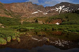
 Reflections of Mount Bierstadt (right) and The Sawtooth (left) | |
| Highest point | |
| Elevation | 14,065 ft (4,287 m)[1][2] |
| Prominence | 720 ft (219 m)[3] |
| Isolation | 1.12 mi (1.80 km)[3] |
| Listing | Colorado Fourteener 38th |
| Coordinates | 39°34′57″N 105°40′08″W / 39.5825981°N 105.6687851°W[1] |
| Naming | |
| Etymology | Albert Bierstadt |
| Geography | |
| Location | Clear Creek County, Colorado, United States[4] |
| Parent range | Front Range, Colorado Peaks[3] |
| Topo map(s) | USGS 7.5' topographic map Mount Evans, Colorado[1] |
| Climbing | |
| First ascent | 1863 Albert Bierstadt[3] |
| Easiest route | West Slopes: Hike, class 2[5] |
Mount Bierstadt is a 14,065-foot-high (4,287 m) mountain summit in the Front Range of the Rocky Mountains, in the U.S. state of Colorado. The fourteener is located in the Mount Evans Wilderness of Pike National Forest, 9.4 miles (15.1 km) south by east (bearing 171°) of the Town of Georgetown in Clear Creek County.[1][2][3][4] It was named in honor of Albert Bierstadt, an American landscape painter who made the first recorded summit of the mountain in 1863.
- ^ a b c d "BIERSTADT". NGS Data Sheet. National Geodetic Survey, National Oceanic and Atmospheric Administration, United States Department of Commerce. Retrieved October 20, 2014.
- ^ a b The elevation of Mount Bierstadt includes an adjustment of +1.790 m (+5.87 ft) from NGVD 29 to NAVD 88.
- ^ a b c d e "Mount Bierstadt, Colorado". Peakbagger.com. Retrieved October 20, 2014.
- ^ a b "Mount Bierstadt". Geographic Names Information System. United States Geological Survey, United States Department of the Interior. Retrieved October 29, 2014.
- ^ "Mt. Bierstadt Routes". 14ers.com.
