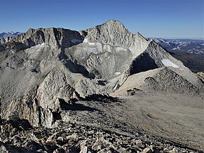
| Mount Conness | |
|---|---|
 from the south, showing Conness Glacier | |
| Highest point | |
| Elevation | 12,590 ft (3,840 m) NAVD 88[1] |
| Prominence | 2,630 ft (802 m)[2] |
| Parent peak | Mount Dana[3] |
| Listing | |
| Coordinates | 37°58′01″N 119°19′17″W / 37.967040447°N 119.321287011°W[1] |
| Geography | |
| Location | Mono / Tuolumne counties, California, U.S. |
| Parent range | Sierra Nevada |
| Topo map | USGS Tioga Pass[2] |
| Climbing | |
| First ascent | 1864 by Clarence King and James T. Gardiner[5] |
| Easiest route | Scramble, class 2[4] |
Mount Conness is a 12,590 foot (3,840 m) mountain in the Sierra Nevada range, to the west of the Hall Natural Area. Conness is on the boundary between the Inyo National Forest and Yosemite National Park. The Conness Glacier lies north of the summit.
- ^ a b "Mount Conness". NGS Data Sheet. National Geodetic Survey, National Oceanic and Atmospheric Administration, United States Department of Commerce. Retrieved 2009-02-23.
- ^ a b "Mount Conness, California". Peakbagger.com. Retrieved 2009-02-23.
- ^ "Mount Conness". ListsOfJohn.com. Retrieved 2012-04-01.
- ^ a b "Sierra Peaks Section List" (PDF). Angeles Chapter, Sierra Club. Retrieved 2009-08-05.
- ^ Whitney, Josiah D. (1870). Yosemite Guide Book. p. 92. Retrieved 2009-01-04.
