| Mount Donna Buang | |
|---|---|
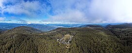
 Aerial view of Mount Donna Buang | |
| Highest point | |
| Elevation | 1,250 m (4,100 ft)[1] |
| Prominence | 470 m (1,540 ft)[1] |
| Isolation | 10.4 km (6.5 mi)[1] |
| Listing | List of mountains in Australia |
| Coordinates | 37°42′23″S 145°40′52″E / 37.70639°S 145.68111°E |
| Geography | |
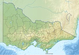
Location in Victoria | |
| Country | Australia |
| State | Victoria |
| Protected area | Yarra Ranges National Park |
| Parent range | Victorian Alps, Great Dividing Range |
Mount Donna Buang ("the body of the mountain" in the language of the Wurundjeri people) [2] is a mountain in the southern reaches of the Victorian Alps of the Great Dividing Range, located in the Australian state of Victoria. Approximately 94 kilometres (58 mi) from Melbourne with an elevation of 1,250 metres (4,101 ft), Mount Donna Buang is the closest snowfield to Melbourne.[3]
- ^ a b c "Mount Donna Buang, Australia". Peakbagger.com. Retrieved 5 June 2023.
- ^ "Mount Donna Buang". eMelbourne - The Encyclopedia of Melbourne Online. The University of Melbourne. Retrieved 3 August 2024.
Located in the Yarra Ranges National Park near Warburton this 1250-m mountain, known to early European settlers as Mount Ackerley or Mount Acland, after the soldier Colonel Acland Anderson, now carries a rendition of its Aboriginal name, meaning 'the body of the mountain'.
- ^ "Yarra Valley Directory". Archived from the original on 13 May 2007.
