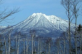
| Mount Eniwa | |
|---|---|
| 恵庭岳 | |
 From Lake Shikotsu, March 2007 | |
| Highest point | |
| Elevation | 1,320 m (4,330 ft)[1] |
| Listing | List of mountains and hills of Japan by height |
| Coordinates | 42°47′36″N 141°17′8″E / 42.79333°N 141.28556°E |
| Geography | |
| Parent range | Nasu Volcanic Zone |
| Topo map(s) | Geographical Survey Institute (国土地理院, Kokudochiriin) 25000:1 恵庭岳, 50000:1 樽前山 |
| Geology | |
| Rock age | Holocene |
| Mountain type | Stratovolcano |
| Volcanic arc | Northeastern Japan Arc |
| Last eruption | 1707 ± 30[2] |
| Climbing | |
| Easiest route | Hike |
Mount Eniwa (恵庭岳, Eniwa-dake) is an active[3] volcano located in Shikotsu-Toya National Park in Hokkaidō, Japan. It sits opposite Mount Tarumae and Mount Fuppushi on the shores of Lake Shikotsu, the caldera lake that spawned the volcanoes. Mount Eniwa is the tallest of the three volcanoes.
- ^ Geological Survey of Japan website Archived 2007-05-26 at archive.today data from ASTER
- ^ "Shikotsu: Eruptive History". Global Volcanism Program. Smithsonian Institution. Retrieved 2008-04-24.
- ^ Paul Hunt, Hiking in Japan: An Adventurer's Guide to the Mountain Trails, pg. 179

