| Mount Everett State Reservation | |
|---|---|
 | |
| Location | Mount Washington, Sheffield, Berkshire, Massachusetts, United States |
| Coordinates | 42°06′06″N 73°25′58″W / 42.10167°N 73.43278°W[1] |
| Area | 2,492 acres (10.08 km2)[2] |
| Elevation | 2,602 ft (793 m)[1] |
| Established | 1908 |
| Operator | Massachusetts Department of Conservation and Recreation |
| Website | Mount Everett State Reservation |
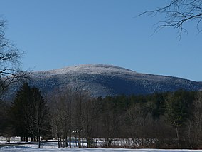
Mount Everett State Reservation is a public recreation area in the towns of Mount Washington and Sheffield, Massachusetts, that offers panoramic views of Massachusetts, Connecticut, and New York from the summit of 2,624-foot (800 m) Mount Everett.[3] The reservation abuts Jug End State Reservation and Wildlife Management Area; Bash Bish Falls State Park and Mount Washington State Forest lie to the west. All are managed by the Massachusetts Department of Conservation and Recreation.
- ^ a b "Mount Everett". Geographic Names Information System. United States Geological Survey, United States Department of the Interior.
- ^ Cite error: The named reference
2012acreagelistwas invoked but never defined (see the help page). - ^ Cite error: The named reference
dcrwas invoked but never defined (see the help page).

