| Mount Faber | |
|---|---|
 | |
| Highest point | |
| Elevation | 348 feet (106 m) |
| Coordinates | 1°16′25.7″N 103°49′03.0″E / 1.273806°N 103.817500°E |
| Naming | |
| Native name | Telok Blangah Hill (Malay) |
| Geography | |
| Location | Singapore |
| Parent range | 56 hectares |
| Geology | |
| Mountain type | hill |
Mount Faber | |
|---|---|
| Name transcription(s) | |
| • Chinese | 花柏山 |
| • Pinyin | Hūa bǎi shān |
| • Malay | Bukit Faber |
| • Tamil | பேபர் மலை |
 | |
| Country | Singapore |
Mount Faber, formerly Telok Blangah Hill, is a hill about 94 metres (308 ft) in height, located in the town of Bukit Merah in the Central Region of Singapore. It overlooks the Telok Blangah area and the western parts of the Central Area. The summit is accessible by Mount Faber Road[1] or Mount Faber Loop via Morse Road, but there are many footpaths or trails leading up the hill. The main paths are: Marang Trail, which leads from Marang Road at the Harbourfront MRT station (Exit D), and the Southern Ridges Park Connector which connects from Telok Blangah Hill Park, Kent Ridge Park, and Henderson Waves.
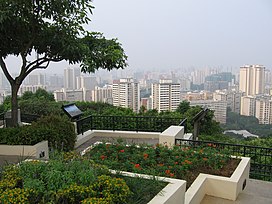
It is a major tourist attraction, as it provides a panoramic view of the dense central business district within the Central Area.[2] Its slope includes a tower that is part of the Singapore cable car system that connects to HarbourFront and Sentosa.[3] It is accessible from the HarbourFront MRT station.
- ^ "Mount Faber Rd closed". The Straits Times. 5 June 1983. p. 15. Retrieved 5 January 2024 – via NewspaperSG.
- ^ Mohamed, Sulaiman (12 April 1972). "Untidy roads at Mt. Faber". New Nation. p. 6. Retrieved 5 January 2024 – via NewspaperSG.
- ^ "Copter used to instal cable car system". The Straits Times. 15 February 1974. p. 11. Retrieved 5 January 2024 – via NewspaperSG.
