| Mount Flume | |
|---|---|
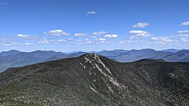
 View of Mount Flume from Mount Liberty | |
| Highest point | |
| Elevation | 4,328 ft (1,319 m) NGVD 29[1] |
| Prominence | 408 ft (124 m)[1] |
| Listing | White Mountain 4000-Footers |
| Coordinates | 44°06′32″N 71°37′40″W / 44.1089549°N 71.6278588°W[2] |
| Geography | |
| Parent range | Franconia Range |
| Topo map | USGS Lincoln |
| Climbing | |
| Easiest route | Hike |
Mount Flume is a 4,328-foot (1,319 m)[1] mountain at the southern end of the Franconia Range in the White Mountains of New Hampshire, United States. Mount Flume is the lowest in elevation of the peaks in the Franconia Range that are accessible by official hiking trails.
The summit marks the western border of the Pemigewasset Wilderness within the White Mountain National Forest. From the summit, there are outstanding views of Franconia Notch and the Kinsman Range to the west and the Franconia Range to the north, with limited views of the Pemigewasset Wilderness and the Twin Range to the east.
- ^ a b c "Mount Flume, New Hampshire". Peakbagger.com. Retrieved 2010-03-23.
- ^ "Mount Flume". Geographic Names Information System. United States Geological Survey, United States Department of the Interior. Retrieved 2010-03-23.

