| Mount Gabriel | |
|---|---|
| Cnoc Osta | |
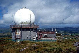
 A radar dome on the summit | |
| Highest point | |
| Elevation | 407 m (1,335 ft)[1] |
| Prominence | 312[1] |
| Listing | Marilyn |
| Coordinates | 51°33.00′N 9°32.19′W / 51.55000°N 9.53650°W |
| Geography | |
| OSI/OSNI grid | V761497 |
| Official name | Mount Gabriel[2] |


Mount Gabriel (Irish: Cnoc Osta) is a mountain on the Mizen Peninsula immediately to the north of the town of Schull in Cork, Ireland. The Gaelic name, Cnoc Osta translates as 'hill of the encampment'.
Mount Gabriel is 407m high and is the highest eminence in the coastal zone south and east of Bantry Bay. A roadway serving the radar installations on the summit is open to the public.
From the peak of Mount Gabriel, there are views south over Schull Harbour and Long Island Bay. To the east and southeast, the views take in Roaringwater Bay and its many islands, known as Carbery's Hundred Isles. North and west are the mountains of the Beara Peninsula and south Kerry.
Fastnet Rock is approximately 18 km to the south, and is visible in fine weather.
- ^ a b "Mizen/Sheeps Head Area – Mount Gabriel". MountainViews.ie. Retrieved 28 May 2015.
- ^ "National Monuments of County Cork in State Care" (PDF). heritageireland.ie. National Monument Service. p. 5. Retrieved 2 July 2020.
