| Mount Graham | |
|---|---|
 Mount Graham, Safford | |
| Highest point | |
| Elevation | 10,724 ft (3,269 m) NAVD 88[1] |
| Prominence | 6,320 ft (1,926 m) (#1 in Arizona)[2] |
| Listing | |
| Coordinates | 32°42′6″N 109°52′17″W / 32.70167°N 109.87139°W[1] |
| Geography | |
| Location | Graham County, Arizona, U.S. |
| Parent range | Pinaleño Mountains |
| Topo map | USGS Mount Graham |
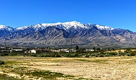
Mount Graham (called in Nnee biyati' (Western Apache) Dził Nchaa Sí'an – 'Big Seated Mountain') is a mountain in Graham County, Arizona, United States, approximately 70 miles (110 km) northeast of Tucson. The mountain reaches 10,724 feet (3,269 m) in height. It is the highest elevation in Graham County, Coronado National Forest and the Pinaleño Mountains.[2] It is also the southernmost peak and land area in the continental United States above 10,000 feet (3,048 m). As the name "Mount Graham" is often used by locals to refer to the entire mountain range, the peak itself is frequently referred to as "High Peak".[4] It is twentieth of the 57 ultra-prominent peaks of the lower 48 states,[5] and the first of the five in Arizona.[6]
- ^ a b "Graham". NGS Data Sheet. National Geodetic Survey, National Oceanic and Atmospheric Administration, United States Department of Commerce. Retrieved February 7, 2014.
- ^ a b "Mount Graham, Arizona". Peakbagger.com. Retrieved February 7, 2014.
- ^ "Arizona County High Points". Peakbagger.com. Retrieved August 14, 2016.
- ^ "Pinaleños Mountains". College of Agriculture and Life Sciences, University of Arizona. Archived from the original on February 21, 2014. Retrieved February 6, 2014.
- ^ "USA Lower 48 Peaks with 5000 feet of Prominence". Peakbagger.com. Retrieved February 6, 2014.
- ^ "Arizona Peaks with 2000 feet of Prominence". Peakbagger.com. Retrieved February 6, 2014.

